Filter: Categories of Wisconsin Historical Images
Filter: Subject of Marshes
Filter: Subject of botany
Filter: Categories of Wisconsin Historical Images
Filter: Subject of Marshes
Filter: Subject of botany

| Date: | 1925 |
|---|---|
| Description: | The Pierre Pauquette monument located at the easterm terminus of the Wauona Trail. Erected by the Wau-bun Chapter of the Daughters of the American Revoluti... |
| Date: | 09 1934 |
|---|---|
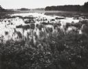
| Description: | View of a cranberry marsh and warehouse. In the foreground is a warehouse for the storage of harvested cranberries. |

| Date: | 1905 |
|---|---|
| Description: | View of town behind a prairie field and a lake. Caption reads: "Packwaukee, Wis." |

| Date: | |
|---|---|
| Description: | At Big Muskegan Wind. In a marsh part of a lake, a man in waders is bent over among the reeds. In the background are three people in a boat, with one perso... |

| Date: | |
|---|---|
| Description: | A man wearing a hat, possibly Ho-Chunk, is mounted bareback on a horse knee-deep in water in a marsh. |
| Date: | |
|---|---|
| Description: | Ho-Chunk lodges among trees. Probably a Ho-Chunk encampment at the cranberry marsh. |

| Date: | |
|---|---|
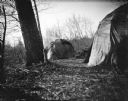
| Description: | Ho-Chunk winter lodges among trees, probably a Ho-Chunk encampment at the cranberry marsh. There are large, cut logs in between two lodges. A small Ho-Chun... |
| Date: | |
|---|---|
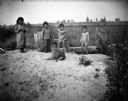
| Description: | Standing together in a row are two Ho-Chunk girls wearing print dresses, and two Ho-Chunk boys who are nude on a sandy pile in front of a marsh. In front o... |
| Date: | |
|---|---|
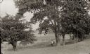
| Description: | A hunter is standing beneath large trees near a marsh holding a rifle. |

| Date: | |
|---|---|
| Description: | A peaceful view of a pond and mill, featuring a small dog sitting in a boat, which rests on the shore. |

| Date: | 1916 |
|---|---|
| Description: | This Wisconsin Conservation Commission map from 1916 shows Peninsula State Park in the Town of Gibraltar, Door County, Wisconsin. Depicted are open and pla... |

| Date: | 1916 |
|---|---|
| Description: | This version of a 1916 Wisconsin Conservation Commission map shows Peninsula State Park in the Town of Gibraltar, Door County, Wisconsin. Depicted are open... |

| Date: | 1975 |
|---|---|
| Description: | This map shows settlers, Indian trails, roads, marshes, and forests as they appeared in 1800-1840. "A bicentennial map of Racine County for the benefit of ... |

| Date: | 1914 |
|---|---|
| Description: | View of a drainage ditch in Horicon Marsh. A man is on a path along the left of the ditch. |

| Date: | 10 1914 |
|---|---|
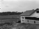
| Description: | View of furrowed ground in Horicon Marsh and men on a tractor in the process of plowing a drained portion of the marsh. |

| Date: | |
|---|---|
| Description: | Elevated view from bluff overlooking the railroad tracks and yard along the Mississippi River. A group of men are gathered on the track near stacks of lumb... |
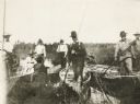
| Date: | 1895 |
|---|---|
| Description: | Group of men, with women passengers, poling canoes through a marshy stretch of water on the Brule River-St. Croix River portage between Lake Superior and t... |

| Date: | |
|---|---|
| Description: | Elevated view of the marsh and silos under a thick fog. |
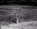
| Date: | 07 12 1964 |
|---|---|
| Description: | Dead tree at the edge of a marsh. The background fades to black. |
If you didn't find the material you searched for, our Library Reference Staff can help.
Call our reference desk at 608-264-6535 or email us at: