 Filter: Categories of Wisconsin Historical Images
Filter: Subject of Marshes
Filter: Subject of architecture
Filter: Categories of Wisconsin Historical Images
Filter: Subject of Marshes
Filter: Subject of architecture
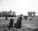
| Date: | 05 26 1963 |
|---|---|
| Description: | Burned cedar stumps in a swamp with a farm in the distance. |

| Date: | 1867 |
|---|---|
| Description: | Bird's-eye map of Green Bay and Fort Howard, Brown Co., depicts street names and street layouts, houses, trees, and the East River. A reference key at the ... |
| Date: | 1900 |
|---|---|
| Description: | Wetland, grassy pasture, ring fence are part of the College of Agriculture Farm on the University of Wisconsin Madison campus. |
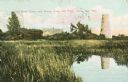
| Date: | 1898 |
|---|---|
| Description: | Caption reads: "Old Stone Tower and House, Long Tail Point, Green Bay, Wis." Water and a marshy area are in the foreground. |

| Date: | 1905 |
|---|---|
| Description: | Long Tail Lighthouse and surrounding buildings. |
| Date: | 1910 |
|---|---|
| Description: | Caption reads: "Old Light House at Long Tail Point, Green Bay, Wis." Built in 1859. A marshy area is in the foreground, and a long pier leads to the new li... |

| Date: | 1906 |
|---|---|
| Description: | Shacks at the foot of North Main Street along Lake Monona near what later became Brittingham Park. |

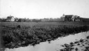
| Date: | 1906 |
|---|---|
| Description: | Area at the foot of West Main Street, which is now Brittingham Park. Weatherworn buildings are on the right. |

| Date: | 1916 |
|---|---|
| Description: | This Wisconsin Conservation Commission map from 1916 shows Peninsula State Park in the Town of Gibraltar, Door County, Wisconsin. Depicted are open and pla... |

| Date: | 1916 |
|---|---|
| Description: | This version of a 1916 Wisconsin Conservation Commission map shows Peninsula State Park in the Town of Gibraltar, Door County, Wisconsin. Depicted are open... |

| Date: | 1858 |
|---|---|
| Description: | This 1858 map of Racine County, Wisconsin, shows land ownership and acreages, the township and range grid, towns, cities and villages, roads, railroads, sc... |

| Date: | 1896 |
|---|---|
| Description: | This late 19th-century map of Dodge County, Wisconsin, shows the township and range grid, towns, sections, cities, villages and post offices, some property... |
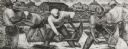
| Date: | |
|---|---|
| Description: | Cranberry harvesters at work. Mural painting in the U.S. Post Office at Berlin, Wis. |

| Date: | 1900 |
|---|---|
| Description: | This photostat of a manuscript map originally drawn in 1829 shows landownership, buildings, including Fort Howard and U.S. sawmill, swamps, public barns an... |

| Date: | 1891 |
|---|---|
| Description: | This map shows soft marshland, water channels, solid ground, club boundary and shooting boxes. Big Lake, First Channel, Second Channel, Fout Mile Pond, Mal... |

| Date: | 06 30 1895 |
|---|---|
| Description: | A man is standing in the right foreground near a tall plant, perhaps corn. In the center is a square-shaped pond with high banks. A man is in the backgroun... |

| Date: | 1759 |
|---|---|
| Description: | Map of New Orleans at the start of the French & Indian War, including two inset maps entitled "The Course of the Mississipi River from Bayagoulas to the Se... |

| Date: | 1769 |
|---|---|
| Description: | Map of New Orleans at the start of the French & Indian War, including two inset maps of the Mississippi River Delta and Fort la Balise. It shows streets, r... |

| Date: | 1761 |
|---|---|
| Description: | Map of New Orleans with north oriented towards the upper right corner. It shows the land around the city, the Mississippi River, anchorages, roads leading ... |
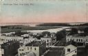
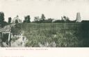
| Date: | 1912 |
|---|---|
| Description: | Bird's-eye view of downtown Fox Lake, with a marshy area and the lake in the background. Caption reads: "Bird's-eye View, Fox Lake, Wis." |
If you didn't find the material you searched for, our Library Reference Staff can help.
Call our reference desk at 608-264-6535 or email us at: