 Filter: Categories of Wisconsin Historical Images
Filter: Subject of Marshes
Filter: County of Dane
Filter: Year of 1900-1999
Filter: Categories of Wisconsin Historical Images
Filter: Subject of Marshes
Filter: County of Dane
Filter: Year of 1900-1999

| Date: | 1904 |
|---|---|
| Description: | Monona Bay from the railroad trestle looking southwest, close to where the railroad tracks cross North Shore Drive, (now Brittingham Park), with old houses... |
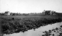
| Date: | 1900 |
|---|---|
| Description: | Wetland, grassy pasture, ring fence are part of the College of Agriculture Farm on the University of Wisconsin Madison campus. |

| Date: | 1906 |
|---|---|
| Description: | Shacks at the foot of North Main Street along Lake Monona near what later became Brittingham Park. |

| Date: | 1906 |
|---|---|
| Description: | Area at the foot of West Main Street, which is now Brittingham Park. Weatherworn buildings are on the right. |

| Date: | 1910 |
|---|---|
| Description: | Shows existing and proposed parks, railroads, and marshes in a color coded key. "Contour interval 20 feet." Lake Wingra, Lake Mendota, and Lake Monona are ... |

| Date: | 1932 |
|---|---|
| Description: | This map shows local streets, section lines, Nakoma Country Club, part of Lake Forest, and part of Lake Wingra. The map includes a legend showing areas of ... |
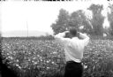
| Date: | 08 10 1957 |
|---|---|
| Description: | Unidentified man taking a picture of the Lotus Bed on Lake Mendota. The bed of large, floating white blossoms are at the peak of their bloom. |
If you didn't find the material you searched for, our Library Reference Staff can help.
Call our reference desk at 608-264-6535 or email us at: