 Filter: Categories of Wisconsin Historical Images
Filter: Subject of Maps
Filter: Categories of Wisconsin Historical Images
Filter: Subject of Maps

| Date: | |
|---|---|
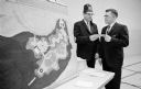
| Description: | Newton Minow and another man are talking while seated in front of a map on the wall. |

| Date: | 1962 |
|---|---|
| Description: | John F. White, president of National Educational Television and Radio Center (left), and Newton Minow, F.C.C. chairman (center) join Eleanor Roosevelt in a... |

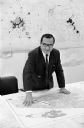
| Date: | |
|---|---|
| Description: | Contact sheet of a photo shoot featuring Newton Minow, holding his eyeglasses and a book and posing with a chair and a television. A large world map is on ... |

| Date: | 07 1986 |
|---|---|
| Description: | A boy in a classroom wears a red necktie with his school uniform. Other children stand around him also wearing red neckties. |

| Date: | 11 1907 |
|---|---|
| Description: | Three men are sitting in an office around a large desk with stacks of books, papers and a telephone. They men are wearing suits, ties and watch fobs, and ... |

| Date: | 01 08 1965 |
|---|---|
| Description: | The new master plan for the Henry Vilas park and zoo is reviewed by Atty. George F. Lange, president of the Henry Vilas Zoological Society, Inc. and Mrs. G... |

| Date: | |
|---|---|
| Description: | Governor John J. Blaine, Wisconsin's 24th governor, sits in an office next to a desk in a leather chair. Papers, books and a telephone are on the desk. On ... |

| Date: | |
|---|---|
| Description: | Former President Jimmy Carter addressing a crowd of people in a classroom. Vel Phillips is on the far left standing next to the President. A group of peopl... |
| Date: | 04 13 1965 |
|---|---|
| Description: | Al Schurch, Mr. Horeb, captain of the Zor Shrine Camel patrol, presents a donation to Paul Hartung, president of the Madison Junior Chamber of Commerce for... |
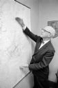
| Date: | 08 13 1965 |
|---|---|
| Description: | H.O. Lord, Madison Metropolitan Sewerage District chief engineer, outlining the existing sewerage district on a map. Lord is trying to educate the public c... |

| Date: | |
|---|---|
| Description: | Map of U.S. divided by county, marked with dots, each representing 50,000 BU wheat in 1840. |

| Date: | |
|---|---|
| Description: | Map of U.S. wheat production, divided by county, marked with dots, each representing 50,000 BU wheat in 1900. |
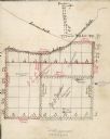
| Date: | |
|---|---|
| Description: | Hand-drawn map detailing acreage of land leased by G.E. Lemmon and J. Walker. |
| Date: | 09 24 1965 |
|---|---|
| Description: | Portrait of Dane County Planning Director Charles Montemayor at a table showing a map of his recently approved re-apportionment plan which would cut the nu... |

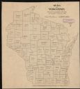
| Date: | 1890 |
|---|---|
| Description: | This map shows the congressional districts lines in accordance with the 1890 census. Districts are labeled by number and color. Original caption reads, "Sh... |

| Date: | 09 1894 |
|---|---|
| Description: | This map shows Congregational churches and Home Missionary churches. County boundaries and county seats are also labeled. The original caption reads, "Cong... |
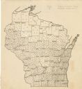
| Date: | 1895 |
|---|---|
| Description: | This map shows the populations for each county in accordance with the census of 1895. The original captions read, " Total population-1,937,915. Diagram sho... |

| Date: | 1896 |
|---|---|
| Description: | This map shows railroads, ordinary roads, good roads, township lines, county lines, county boundaries, towns, lakes, and rivers in the southeastern part ... |
| Date: | 1923 |
|---|---|
| Description: | This map shows the county boundaries, with each dot representing 50 silos. |

| Date: | 1898 |
|---|---|
| Description: | This map shows the conditions of the forest. Includes a color legend in left margin, depicting the various conditions. Original caption reads, "Compiled by... |
If you didn't find the material you searched for, our Library Reference Staff can help.
Call our reference desk at 608-264-6535 or email us at: