 Filter: Categories of Wisconsin Historical Images
Filter: Subject of Maps
Filter: Year of 1900-1999
Filter: Year of 1930-1939
Filter: Categories of Wisconsin Historical Images
Filter: Subject of Maps
Filter: Year of 1900-1999
Filter: Year of 1930-1939

| Date: | 1936 |
|---|---|
| Description: | View across road of a one-story building, Day's Service Station, with gasoline pumps and signs and a map out front. The signs read “Straight Ahead, 10 Mi. ... |

| Date: | 1932 |
|---|---|
| Description: | Map of the Middle East accompanying an article on International's involvement in building the Iraq Pipe Line. Headline text on the page reads: "Internation... |
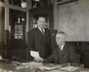
| Date: | 1935 |
|---|---|
| Description: | Assistant Superintendent C.M. Harrison (left) and Superintendent E.C. Lutz look at a document in an office at International Harvester's Ft. Wayne Works. A ... |

| Date: | 1931 |
|---|---|
| Description: | Students work at their desks in the Mayo School, District No. 1. A row of books forms the foreground; history lessons from the time of reconstruction after... |
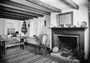
| Date: | 1936 |
|---|---|
| Description: | View of a room in Pendarvis House. There is a map of Cornwall over the fireplace. A bedwarmer and a bellows sit at the base of the hearth. |

| Date: | 1933 |
|---|---|
| Description: | A road map of Wisconsin, that shows the major and some minor roads of the state, population of the cities and towns, a scale and an index. The reverse side... |

| Date: | 1934 |
|---|---|
| Description: | This map features a road map with a legend and scale. The bigger cities and towns are highlighted in green. The back of the map includes an index, advertis... |

| Date: | 1934 |
|---|---|
| Description: | A road map of Wisconsin sponsored by Conoco. The front side includes and index, scale, and legend. The reverse side includes United States road map, and i... |

| Date: | 1934 |
|---|---|
| Description: | Road map of Wisconsin compliments of Phillips Petroleum Company. The front side includes an index and scale. The reverse side shows a generic road map of t... |

| Date: | 1939 |
|---|---|
| Description: | This map originally dated March 18, 1920 and revised for this edition. The map shows the original meander line of 'Shebowegan Lake' established by 1850 sur... |

| Date: | 1935 |
|---|---|
| Description: | This map is presented by Conoco, and shows the major roads, cities, lakes, and rivers, as well as some of the neighboring states. It includes an index, sca... |

| Date: | 1935 |
|---|---|
| Description: | This blue lined map shows the major roads and cities of Wisconsin. The map includes an index, hotel and cafe advertisements, as well as advertisements for ... |

| Date: | 1935 |
|---|---|
| Description: | This blue lined map ("compliments of Black Eagle Oil Company") shows the major roads and cities of Wisconsin. The map includes an index, hotel and cafe adv... |

| Date: | 1930 |
|---|---|
| Description: | This map shows roads and lakes and includes an inset illustration of Manitowish Waters Fish Hatchery. The back of the map includes a resorts directory, tex... |

| Date: | 1937 |
|---|---|
| Description: | This map shows the major roads, cities, towns, lakes, and rivers of Wisconsin and some of the neighboring states. The front includes an add for Coca-Cola, ... |

| Date: | 1937 |
|---|---|
| Description: | This map shows the major cities, towns, highways, roads, lakes, and rivers of Wisconsin and some of the neighboring states. An index is included on the fro... |

| Date: | 1931 |
|---|---|
| Description: | This photocopy map shows lot and block numbers, some landownership and acreages, water flowage, and marshes. The map also shows Lake Menomin and Wilson Cr... |

| Date: | 1937 |
|---|---|
| Description: | This cadastral map shows lots, streets, and Pell Lake. The back of the map includes a large advertisement for the Pell Lake Addition summer home lots. |

| Date: | 1930 |
|---|---|
| Description: | This map shows the entire state plus portions of Illinois, Iowa, Minnesota, and Michigan outlined in blue. The map shows roads, state parks (black triangle... |

| Date: | 1937 |
|---|---|
| Description: | Map showing territory controlled by the Finches, a family of bandits who terrorized south central Wisconsin in the years prior to the Civil War. The map in... |
If you didn't find the material you searched for, our Library Reference Staff can help.
Call our reference desk at 608-264-6535 or email us at: