 Filter: Categories of Wisconsin Historical Images
Filter: Subject of Maps
Filter: Year of 1900-1999
Filter: Subject of trees
Filter: Categories of Wisconsin Historical Images
Filter: Subject of Maps
Filter: Year of 1900-1999
Filter: Subject of trees
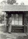
| Date: | 1939 |
|---|---|
| Description: | Man looking at a map of Copper Falls State Park, which is on display to assist visitors. |

| Date: | 1920 |
|---|---|
| Description: | Calumet Harbor on Lake Winnebago. On the left is a map, and on the right are two images, one captioned: "Calumet Harbor". |

| Date: | 1924 |
|---|---|
| Description: | Front and back covers of Scenic Wisconsin Motorways, a guide to Wisconsin roads compiled by Victor F. Pettric and published by the Wisconsin Motorists Asso... |
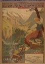
| Date: | 1900 |
|---|---|
| Description: | An original colored lithograph advertising the Chemins de Fer électrique du Valais à Chamonix (Electric Railways of Valais in Chamonix) railway. The poster... |

| Date: | 1948 |
|---|---|
| Description: | Holiday card of the history of the State of Wisconsin, 1848-1948. Shows a map of Wisconsin with many historical and themed elements. Image was created by w... |

| Date: | 1950 |
|---|---|
| Description: | Holiday card with the "family tree" of D.C. III (David Clark Everest) and Rita Everest, on the front, and a map of the U.S.A. on the inside showing the two... |

| Date: | 1969 |
|---|---|
| Description: | Photographic holiday postcard of a couple on their bikes in a driveway. Shrubs and palm trees surround them. A map of the Pacific Ocean is in the backgroun... |

| Date: | 1950 |
|---|---|
| Description: | Agricultural exhibit designed by the Wisconsin State Cranberry Growers Association and Eatmor Cranberries. The exhibit shows various types and stages of cr... |

| Date: | 1958 |
|---|---|
| Description: | Meeting of the 26th of July Movement in Oriente Province during the Cuban Revolution. Vilma Espin and Fidel Castro crouch over a map spread on the ground.... |

| Date: | 1936 |
|---|---|
| Description: | View across road of a one-story building, Day's Service Station, with gasoline pumps and signs and a map out front. The signs read “Straight Ahead, 10 Mi. ... |

| Date: | 1943 |
|---|---|
| Description: | View across road of Day's Service Station with gasoline pumps, maps and signs out front. The right half of the building is one-story high, and the left hal... |
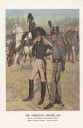
| Date: | 1976 |
|---|---|
| Description: | "A general staff officer stands in the left foreground in the single-breasted blue coat with black herringbone false buttonholes on the chest and cuffs and... |

| Date: | 07 1987 |
|---|---|
| Description: | "Andy Schnitzler holds the plans for the 'River View Mobile Home Park' which will be developed in the fields behind." |

| Date: | 03 1998 |
|---|---|
| Description: | "Village officials help kick off Valley Estates Subdivision." |

| Date: | 1901 |
|---|---|
| Description: | Catalog cover with the title: "The Three Greatest Empires," features an illustration of an Empire Drill in the foreground, and in the background a train tr... |

| Date: | 1910 |
|---|---|
| Description: | Fred Carr and Bill Marr reading a map together while sitting on the ground. |

| Date: | 1910 |
|---|---|
| Description: | The Gang is sitting on their packs or bedrolls as they consult their maps with a ranger. |

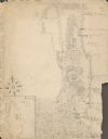
| Date: | 01 13 1937 |
|---|---|
| Description: | Sketch map of Township 7 North, Range 9 East, created for the Land Economic Inventory (Bordner Survey). The map shows Picnic Point and the Lake Mendota sho... |

| Date: | 11 1964 |
|---|---|
| Description: | Fold-out map of the zoo inside a publication titled: "Henry Vilas Park Zoo: An Instructive Book on the Origin and Habits of Animals." Includes Lake Wingra,... |
| Date: | 1929 |
|---|---|
| Description: | An unsigned, hand-drawn map of properties owned by members of the Brumder family on the northwest shore of Pine Lake in 1929. Named Villa Henrietta, the pr... |
If you didn't find the material you searched for, our Library Reference Staff can help.
Call our reference desk at 608-264-6535 or email us at: