 Filter: Categories of Wisconsin Historical Images
Filter: Subject of Maps
Filter: Year of 1900-1999
Filter: Subject of transportation
Filter: Categories of Wisconsin Historical Images
Filter: Subject of Maps
Filter: Year of 1900-1999
Filter: Subject of transportation

| Date: | 1990 |
|---|---|
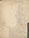
| Description: | This map, in addition to the Fort ground and buildings, shows owners of outbuildings, heights of buildings in stories, fences, roads, gardens, and cemetery... |

| Date: | 1966 |
|---|---|
| Description: | This blue line print shows existing and proposed streets, docks, company-owned land, railroads and railroad yards, parks, and municipal airport. |

| Date: | 1937 |
|---|---|
| Description: | Map showing territory controlled by the Finches, a family of bandits who terrorized south central Wisconsin in the years prior to the Civil War. The map in... |
| Date: | 1910 |
|---|---|
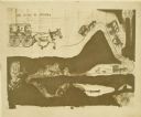
| Description: | Carl Greene's drawing of a map of The Gang's trip to Winton, titled "We drive to Winton." This map shows a road currently known as the Thirteen Corners Roa... |

| Date: | 1938 |
|---|---|
| Description: | Front cover of "At Home Abroad" brochure. |
| Date: | 1938 |
|---|---|
| Description: | Back cover of "At Home Abroad" brochure featuring the continent of Australia. |

| Date: | 1938 |
|---|---|
| Description: | Inside spread of "At Home Abroad" brochure. The title reads: "A World-wide Sales and Service Organization." Features a map of the continents of the world. ... |

| Date: | 10 31 1928 |
|---|---|
| Description: | A "Sahara" truck, loaded heavily with sandbags, is sitting in deep sand in an exhibition at a fair. A large building is in the background. |
| Date: | 12 22 1953 |
|---|---|
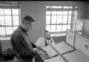
| Description: | Chief of weather operations, L.A. Joos, is on the telephone, while W.C. Williamson is standing at a slanted desk checking one of several weather maps. They... |
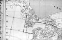
| Date: | 1929 |
|---|---|
| Description: | An unsigned, hand-drawn map of properties owned by members of the Brumder family on the northwest shore of Pine Lake in 1929. Named Villa Henrietta, the pr... |

| Date: | 10 31 1928 |
|---|---|
| Description: | Rear view of the "Sahara" truck, with the back heavily loaded with sandbags, driving through deep sand at an exhibition. There is a map on a signboard in t... |

| Date: | 10 31 1928 |
|---|---|
| Description: | Left side view of the "Sahara" truck, with the back heavily loaded with sandbags, sitting in deep sand at an exhibition. There is a map on a signboard in t... |
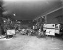
| Date: | 02 07 1929 |
|---|---|
| Description: | The Sahara truck on display with information panels. Other vehicles are on display in the large room. |
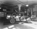
| Date: | 03 18 1929 |
|---|---|
| Description: | "The Truck that Crossed the Sahara" on display in a showroom. |
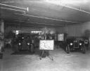
| Date: | 03 26 1929 |
|---|---|
| Description: | "Truck That Crossed The Sahara" is on display in a dealership. In the foreground is a map on an easel. |
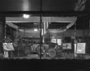
| Date: | 04 06 1929 |
|---|---|
| Description: | View through a show window of a display of the truck that crossed the Sahara. There is a map on an easel on the left. A poster on an easel on the right has... |
| Date: | 06 1960 |
|---|---|
| Description: | Photograph of street map of the Village of Shorewood Hills and Blackhawk Country Club. Lake Mendota is at the top of the map. |

| Date: | 1941 |
|---|---|
| Description: | Advertising proof. Uncle Sam is standing by a map labeled "Service. Each dot an International Company-Owned Branch." Title above text at bottom reads: "Int... |
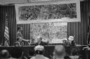
| Date: | 11 09 1960 |
|---|---|
| Description: | A display to illustrate proposed improvements to the Madison Beltline highway at a hearing in the City-County Building by the State Highway Commission. |
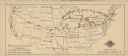
| Date: | 1924 |
|---|---|
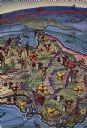
| Description: | Map of the United States with tour route taken by the Chicago Civic Opera Company indicated in red. The company traveled on the Baltimore & Ohio Railroad S... |
If you didn't find the material you searched for, our Library Reference Staff can help.
Call our reference desk at 608-264-6535 or email us at: