 Filter: Categories of Wisconsin Historical Images
Filter: Subject of Maps
Filter: Year of 1900-1999
Filter: Subject of roads
Filter: Categories of Wisconsin Historical Images
Filter: Subject of Maps
Filter: Year of 1900-1999
Filter: Subject of roads

| Date: | 1924 |
|---|---|
| Description: | Front and back covers of Scenic Wisconsin Motorways, a guide to Wisconsin roads compiled by Victor F. Pettric and published by the Wisconsin Motorists Asso... |
| Date: | 11 25 1947 |
|---|---|
| Description: | Elevated view of eleven men sitting on the stage at Central High School auditorium conducting a hearing on the possibility of putting West Washington Avenu... |

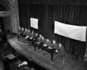
| Date: | 11 25 1947 |
|---|---|
| Description: | Lowell Frautschi, Vice President Frautschi's Furniture Store, speaking at a hearing on the possibility of putting West Washington Avenue under the Chicago,... |

| Date: | 08 1971 |
|---|---|
| Description: | Poster advertising for an event occurring between August 1971 and February 1972 called the "Traffic Experiment," in Madison. Features screen printed silhou... |

| Date: | 1959 |
|---|---|
| Description: | University of Wisconsin-Madison campus. Numbers in circles identify buildings across campus with the building index. Black arrows point out important infor... |

| Date: | 1930 |
|---|---|
| Description: | Exterior view of the Triangle filling station on Highway 12, which sold gasoline, ice, and other items. A man stands in front by the gas pump, and a map of... |
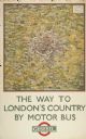
| Date: | 1924 |
|---|---|
| Description: | An original colored lithograph advertising the "The Way to London's Country by Motor Bus" using the Underground Electric Railway Company's motor bus servic... |
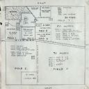
| Date: | 01 24 1924 |
|---|---|
| Description: | Plot for an International Harvester Company demonstration farm. |

| Date: | 1936 |
|---|---|
| Description: | View across road of a one-story building, Day's Service Station, with gasoline pumps and signs and a map out front. The signs read “Straight Ahead, 10 Mi. ... |

| Date: | 1943 |
|---|---|
| Description: | View across road of Day's Service Station with gasoline pumps, maps and signs out front. The right half of the building is one-story high, and the left hal... |
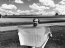
| Date: | 07 1987 |
|---|---|
| Description: | "Andy Schnitzler holds the plans for the 'River View Mobile Home Park' which will be developed in the fields behind." |

| Date: | 1902 |
|---|---|
| Description: | This map shows townships, land parcels, schools, rivers, lakes, creameries, churches, cemeteries, roads, post offices, town halls, saw mills, roads and sto... |

| Date: | 1933 |
|---|---|
| Description: | A road map of Wisconsin, that shows the major and some minor roads of the state, population of the cities and towns, a scale and an index. The reverse side... |

| Date: | 1934 |
|---|---|
| Description: | This map features a road map with a legend and scale. The bigger cities and towns are highlighted in green. The back of the map includes an index, advertis... |

| Date: | 1934 |
|---|---|
| Description: | A road map of Wisconsin sponsored by Conoco. The front side includes and index, scale, and legend. The reverse side includes United States road map, and i... |

| Date: | 1934 |
|---|---|
| Description: | Road map of Wisconsin compliments of Phillips Petroleum Company. The front side includes an index and scale. The reverse side shows a generic road map of t... |

| Date: | 1928 |
|---|---|
| Description: | A Wisconsin state highway map, featuring the major highways, rivers, lakes, and cities. There are a few advertisements on the front and back. The back also... |

| Date: | 1906 |
|---|---|
| Description: | This map shows the cities, counties (outlined in yellow and labeled), rivers, lakes, and the major highways and freeways of Wisconsin and parts of the surr... |

| Date: | 1910 |
|---|---|
| Description: | This map of shows railway lines in red, with railroad land grant in Taylor, Price, and Ashland Counties shaded red, on top of the cities, counties, highway... |

| Date: | 1924 |
|---|---|
| Description: | This map shows railroads, electric lines, and steamship lines. The left margin includes an index of principal cities, and the lower left corner includes a... |
If you didn't find the material you searched for, our Library Reference Staff can help.
Call our reference desk at 608-264-6535 or email us at: