 Filter: Categories of Wisconsin Historical Images
Filter: Subject of Maps
Filter: Year of 1900-1999
Filter: County of Walworth
Filter: Categories of Wisconsin Historical Images
Filter: Subject of Maps
Filter: Year of 1900-1999
Filter: County of Walworth
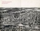
| Date: | 1909 |
|---|---|
| Description: | Illustration of town. Caption reads: "Bird's-eye View, Lyons, Wisconsin. A Village of natural environments, choice residence locations, desirable factory s... |
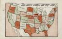
| Date: | 1905 |
|---|---|
| Description: | Map of the United States with an imprint of Whitewater, Wisconsin and the title "The Only Town on the Map". It was published as a novelty. |

| Date: | 1946 |
|---|---|
| Description: | W.V.B. Holloway, Richard Quinney's maternal grandfather, sitting at a a table looking at a large book of maps. A phone is mounted to the wall next to him ... |

| Date: | 1937 |
|---|---|
| Description: | This cadastral map shows lots, streets, and Pell Lake. The back of the map includes a large advertisement for the Pell Lake Addition summer home lots. |
If you didn't find the material you searched for, our Library Reference Staff can help.
Call our reference desk at 608-264-6535 or email us at: