 Filter: Categories of Wisconsin Historical Images
Filter: Subject of Maps
Filter: Year of 1900-1999
Filter: Creator Name of Unknown
Filter: Year of 1920-1929
Filter: Categories of Wisconsin Historical Images
Filter: Subject of Maps
Filter: Year of 1900-1999
Filter: Creator Name of Unknown
Filter: Year of 1920-1929

| Date: | 1926 |
|---|---|
| Description: | Pages 21 and 22 from the 1926 schedule are a map showing the routes of the Goodrich Transit Company, Great Lakes Transit Company, Detroit and Cleveland Lin... |

| Date: | 1920 |
|---|---|
| Description: | Calumet Harbor on Lake Winnebago. On the left is a map, and on the right are two images, one captioned: "Calumet Harbor". |

| Date: | 1925 |
|---|---|
| Description: | A map of the farm planned by Edwin Bottomley in 1844. |

| Date: | 1924 |
|---|---|
| Description: | Front and back covers of Scenic Wisconsin Motorways, a guide to Wisconsin roads compiled by Victor F. Pettric and published by the Wisconsin Motorists Asso... |
| Date: | 1920 |
|---|---|
| Description: | Map of Wisconsin showing native Polish populations by county. |
| Date: | 1923 |
|---|---|
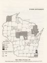
| Description: | This map shows the county boundaries, with each dot representing 50 silos. |

| Date: | 1925 |
|---|---|
| Description: | Map of northern Africa with the border between Algeria and Tunisia drawn in red. Caption reads: "199A — (L61208) Map Series 2 The Eastern Barbary States." |

| Date: | 1929 |
|---|---|
| Description: | An unsigned, hand-drawn map of properties owned by members of the Brumder family on the northwest shore of Pine Lake in 1929. Named Villa Henrietta, the pr... |

| Date: | 1925 |
|---|---|
| Description: | Equipment is set-up in a laboratory at Trout Lake. A map of Oneida County is on the far wall between two windows. |

| Date: | 1920 |
|---|---|
| Description: | Sigrid Schultz is seated at a desk holding a document. A man is typing at a desk behind her. There is a map on the wall. |
If you didn't find the material you searched for, our Library Reference Staff can help.
Call our reference desk at 608-264-6535 or email us at: