 Filter: Categories of Wisconsin Historical Images
Filter: Subject of Maps
Filter: Year of 1900-1999
Filter: Type of Map or Atlas
Filter: Year of 1970-1979
Filter: Categories of Wisconsin Historical Images
Filter: Subject of Maps
Filter: Year of 1900-1999
Filter: Type of Map or Atlas
Filter: Year of 1970-1979
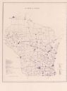
| Date: | 1974 |
|---|---|
| Description: | This blue line map show gas services and county boundaries. Includes a legend of company names in lower left hand corner. |
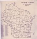
| Date: | 11 1973 |
|---|---|
| Description: | This map shows the cities, county boundaries and telephone exchange locations. The map includes a numbered list of telephone companies. |
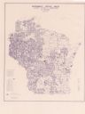
| Date: | 06 1975 |
|---|---|
| Description: | This map shows electrical utilities and cooperatives throughout the state, as well as cities and county boundaries. The bottom left corner of the map inclu... |

| Date: | 1975 |
|---|---|
| Description: | This map shows nature trails, public attractions, public hunting and fishing grounds, dams, waysides, lakes, highways, and roads. The upper right corner in... |

| Date: | 1974 |
|---|---|
| Description: | This map draws content from a map originally created by George Featherstongaugh in 1840. The map shows streets, land ownership, the Brotherton Indian reser... |
If you didn't find the material you searched for, our Library Reference Staff can help.
Call our reference desk at 608-264-6535 or email us at: