 Filter: Categories of Wisconsin Historical Images
Filter: Subject of Maps
Filter: Year of 1900-1999
Filter: Type of Map or Atlas
Filter: Year of 1920-1929
Filter: Categories of Wisconsin Historical Images
Filter: Subject of Maps
Filter: Year of 1900-1999
Filter: Type of Map or Atlas
Filter: Year of 1920-1929

| Date: | 1926 |
|---|---|
| Description: | Pages 21 and 22 from the 1926 schedule are a map showing the routes of the Goodrich Transit Company, Great Lakes Transit Company, Detroit and Cleveland Lin... |

| Date: | 1925 |
|---|---|
| Description: | A map of the farm planned by Edwin Bottomley in 1844. |
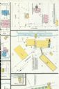
| Date: | 07 1929 |
|---|---|
| Description: | A detail of a Sanborn map of Grafton including the New York Recording Laboratory. |
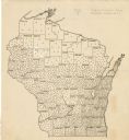
| Date: | 1923 |
|---|---|
| Description: | This map shows the county boundaries, with each dot representing 50 silos. |

| Date: | 1928 |
|---|---|
| Description: | A Wisconsin state highway map, featuring the major highways, rivers, lakes, and cities. There are a few advertisements on the front and back. The back also... |

| Date: | 1924 |
|---|---|
| Description: | This map shows railroads, electric lines, and steamship lines. The left margin includes an index of principal cities, and the lower left corner includes a... |

| Date: | 1920 |
|---|---|
| Description: | This map shows lands owned by the American Immigration Company (red) and the Homeseekers Land Company (green). The map also shows highways, roads, railroad... |

| Date: | 1925 |
|---|---|
| Description: | This map shows trails, mounds, villages, corn fields, and contemporary civil townships; some villages and features include both Indian and English place na... |

| Date: | 1926 |
|---|---|
| Description: | This blueprint map is oriented with north to the upper left. The map shows buildings with note of those "to be torn down," sidewalks, proposed power plant,... |

| Date: | 1927 |
|---|---|
| Description: | This map details automobile routes throughout the state as well as parts of Iowa, Minnesota, Michigan and Illinois. Cities, the Mississippi River, Lake Mic... |

| Date: | 1920 |
|---|---|
| Description: | This map details automobile routes spanning across Wisconsin and parts of Illinois, Michigan, Minnesota, and Iowa. Cities, counties, Lake Michigan, Lake Su... |

| Date: | 1924 |
|---|---|
| Description: | This map shows automobile routes across the state and into parts of Minnesota, Iowa, Illinois, and Michigan. Cities, Lake Michigan, Lake Superior, Green Ba... |

| Date: | 1920 |
|---|---|
| Description: | This map shows the entire state as well as portions of Iowa, Illinois, Minnesota, and Michigan. Counties outlined in yellow, cities, rivers, lakes, and rai... |

| Date: | 1920 |
|---|---|
| Description: | The map shows the entire state with cities, rivers, and lakes labeled. The upper and right margin include inset maps of Racine, Milwaukee, Waukesha, Applet... |

| Date: | 1929 |
|---|---|
| Description: | This map of the entire state includes portions of Illinois, Iowa, Michigan, and Minnesota. The map shows U.S., state, and county highways, roads, campsites... |

| Date: | 1920 |
|---|---|
| Description: | This map of the entire state shows state and other highways, cities, some lake, the Mississippi River, Lake Michigan, and Lake Superior. The bottom left co... |

| Date: | 1925 |
|---|---|
| Description: | The map shows the entire state with portions of Illinois, Iowa, Minnesota, and Michigan. The map shows concrete, gravel, all weather earth, clay, and sand ... |

| Date: | 1929 |
|---|---|
| Description: | This map shows the entire state of Wisconsin and Minnesota and portions of Illinois and Iowa. Counties, cities, highways, lakes, and rivers are labeled. Ro... |
If you didn't find the material you searched for, our Library Reference Staff can help.
Call our reference desk at 608-264-6535 or email us at: