Filter: Categories of Wisconsin Historical Images
Filter: Subject of Maps
Filter: Year of 1800-1899
Filter: Categories of Wisconsin Historical Images
Filter: Subject of Maps
Filter: Year of 1800-1899
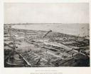
| Date: | 1892 |
|---|---|
| Description: | Bird's-eye view of Cudahy showing stock yards and the Cudahy packing houses. A train runs through the center of the image on the Chicago & Northwestern Rai... |

| Date: | 1865 |
|---|---|
| Description: | Portrait of Reverend Edward Mathews standing in front of a "Moral Map of the United States." He is holding a long, wooden pointer and is gesturing towards ... |

| Date: | 1838 |
|---|---|
| Description: | Drawing of Shullsburg. There is a numbered key on the left that reads, at top: "Explanation. Nos. Denote present Site." Streets are named on the map and ma... |

| Date: | 1866 |
|---|---|
| Description: | Diagram and seating chart for the Wisconsin State Senate in the second State Capitol Building which burned down in 1904. |

| Date: | 1866 |
|---|---|
| Description: | Diagram and seating chart for the Wisconsin State Assembly in the second State Capitol Building which burned down in 1904.. |
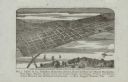
| Date: | 1880 |
|---|---|
| Description: | Bird's-eye map of the city of Madison. Caption reads: "City of Madison — From Park's 'History of Madison, Dane County, and Surrounding Towns.'" The text un... |

| Date: | 1867 |
|---|---|
| Description: | A map and profile map of the railroad line from Omaha to San Francisco. |
If you didn't find the material you searched for, our Library Reference Staff can help.
Call our reference desk at 608-264-6535 or email us at: