Filter: Categories of Wisconsin Historical Images
Filter: Subject of Maps
Filter: Year of 1800-1899
Filter: Creator Name of Unknown
Filter: Categories of Wisconsin Historical Images
Filter: Subject of Maps
Filter: Year of 1800-1899
Filter: Creator Name of Unknown

| Date: | 07 1838 |
|---|---|
| Description: | A map diagram of Indian effigy mounds seven miles east of Blue Mounds in the Wisconsin Territory. |
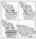
| Date: | 01 11 1805 |
|---|---|
| Description: | Four map illustrations showing the political subdivisions of the Northwest Territory from 1805 through 1834. |

| Date: | 1836 |
|---|---|
| Description: | The map of Wisconsin City on the Wisconsin River. |

| Date: | 1855 |
|---|---|
| Description: | Fox-Wisconsin portage and canal map, when the canal was not yet built. From a map in the office of the city clerk at Portage. "The old trail, the location ... |
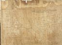
| Date: | 1857 |
|---|---|
| Description: | Plat map of Kekoskee, Wisconsin. Kekoskee is a village in Dodge County, in the Beaver Dam metropolitan area. The community name derives from Indian term fo... |

| Date: | 1887 |
|---|---|
| Description: | A bird's-eye map of Menekaune, Menominee and Marinette. |

| Date: | 02 1823 |
|---|---|
| Description: | A map featuring the North American expedition from Pittsburgh to the Rocky Mountains led by Edwin James. |

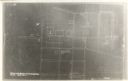
| Date: | 1895 |
|---|---|
| Description: | Two men in a small office, probably a railroad station. On the right is a map on the wall, and below it is a Herring Hall Marvin safe. |
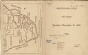
| Date: | 11 14 1899 |
|---|---|
| Description: | Front and back covers of the first dinner of the Six O'Clock Club held at the Park Hotel, with a map on the back cover of the southern tip of Africa, with ... |
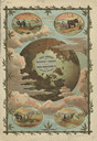
| Date: | 1884 |
|---|---|
| Description: | Front cover of catalog featuring a color illustration of a globe among clouds. Small oval inset illustrations are of farmers working in fields in Africa, A... |

| Date: | 1890 |
|---|---|
| Description: | This map shows the congressional districts lines in accordance with the 1890 census. Districts are labeled by number and color. Original caption reads, "Sh... |

| Date: | 09 1894 |
|---|---|
| Description: | This map shows Congregational churches and Home Missionary churches. County boundaries and county seats are also labeled. The original caption reads, "Cong... |

| Date: | 1896 |
|---|---|
| Description: | Front cover and interior of banquet menu for Mexican President Porfirio Diaz, to celebrate the construction of a drainage canal between Lake Texcoco and La... |

| Date: | 1800 |
|---|---|
| Description: | Map of the United States. It shows the states, including Tennessee, cities, towns, Native American land, mountains, lakes, and rivers. Lead mines appear ju... |

| Date: | 1865 |
|---|---|
| Description: | Portrait of Reverend Edward Mathews standing in front of a "Moral Map of the United States." He is holding a long, wooden pointer and is gesturing towards ... |
If you didn't find the material you searched for, our Library Reference Staff can help.
Call our reference desk at 608-264-6535 or email us at: