 Filter: Categories of Wisconsin Historical Images
Filter: Subject of Maps
Filter: Subject of water
Filter: Categories of Wisconsin Historical Images
Filter: Subject of Maps
Filter: Subject of water

| Date: | |
|---|---|
| Description: | Exterior of the menu for Paul's Cafe, with a bird's-eye view map of "Washburn's Natural Deep Water Land Locked Harbor," Chequamegon Bay, and the Apostle Is... |
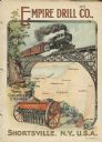
| Date: | 1901 |
|---|---|
| Description: | Catalog cover with the title: "The Three Greatest Empires," features an illustration of an Empire Drill in the foreground, and in the background a train tr... |
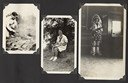
| Date: | |
|---|---|
| Description: | Page from Joy Camps photo album displaying three photographs. In one photograph Barbara Ellen Joy, camp owner and co-director, cooks over a large grill are... |
| Date: | 1950 |
|---|---|
| Description: | Export map for International Harvester products manufactured in Australia at the company's Geelong and Dandenong Works. |
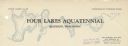
| Date: | |
|---|---|
| Description: | Letterhead of the Four Lakes Aquatennial, sponsored by the Four Lakes Club and the Veterans of Foreign Wars, with a background illustration of the chain of... |

| Date: | 1966 |
|---|---|
| Description: | A colored map depiction of Door County, Wisconsin, with pictorial highlights, titled: "Door County — Wisconsin's Air Conditioned Peninsula Playground." |

| Date: | 04 15 1915 |
|---|---|
| Description: | A sketch of Little Lake Butte des Morts and the surrounding area, including Neenah and Menasha. |

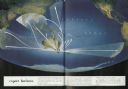
| Date: | 1950 |
|---|---|
| Description: | Inside spread illustration of the world, with a legend indicating: Subsidiary Company, Branch of Subsidiary, Representative, Works, and Distributor. |
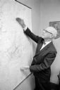
| Date: | 08 13 1965 |
|---|---|
| Description: | H.O. Lord, Madison Metropolitan Sewerage District chief engineer, outlining the existing sewerage district on a map. Lord is trying to educate the public c... |

| Date: | 1896 |
|---|---|
| Description: | This map shows railroads, ordinary roads, good roads, township lines, county lines, county boundaries, towns, lakes, and rivers in the southeastern part ... |

| Date: | 1898 |
|---|---|
| Description: | This map shows the conditions of the forest. Includes a color legend in left margin, depicting the various conditions. Original caption reads, "Compiled by... |

| Date: | 1916 |
|---|---|
| Description: | This map shows railroads, cities, rivers, lakes, and county boundaries. Select railroads are outlined in red. Portions of western Wisconsin Minnesota are v... |

| Date: | 1896 |
|---|---|
| Description: | Front cover and interior of banquet menu for Mexican President Porfirio Diaz, to celebrate the construction of a drainage canal between Lake Texcoco and La... |

| Date: | 1902 |
|---|---|
| Description: | This map shows townships, land parcels, schools, rivers, lakes, creameries, churches, cemeteries, roads, post offices, town halls, saw mills, roads and sto... |

| Date: | 1933 |
|---|---|
| Description: | A road map of Wisconsin, that shows the major and some minor roads of the state, population of the cities and towns, a scale and an index. The reverse side... |

| Date: | 1934 |
|---|---|
| Description: | This map features a road map with a legend and scale. The bigger cities and towns are highlighted in green. The back of the map includes an index, advertis... |

| Date: | 1934 |
|---|---|
| Description: | A road map of Wisconsin sponsored by Conoco. The front side includes and index, scale, and legend. The reverse side includes United States road map, and i... |

| Date: | 1934 |
|---|---|
| Description: | Road map of Wisconsin compliments of Phillips Petroleum Company. The front side includes an index and scale. The reverse side shows a generic road map of t... |

| Date: | 1928 |
|---|---|
| Description: | A Wisconsin state highway map, featuring the major highways, rivers, lakes, and cities. There are a few advertisements on the front and back. The back also... |

| Date: | 1906 |
|---|---|
| Description: | This map shows the cities, counties (outlined in yellow and labeled), rivers, lakes, and the major highways and freeways of Wisconsin and parts of the surr... |
If you didn't find the material you searched for, our Library Reference Staff can help.
Call our reference desk at 608-264-6535 or email us at: