 Filter: Categories of Wisconsin Historical Images
Filter: Subject of Maps
Filter: Subject of water
Filter: Categories of Wisconsin Historical Images
Filter: Subject of Maps
Filter: Subject of water

| Date: | 1959 |
|---|---|
| Description: | University of Wisconsin-Madison campus. Numbers in circles identify buildings across campus with the building index. Black arrows point out important infor... |
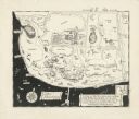
| Date: | |
|---|---|
| Description: | A pen drawing, in the style of a birds-eye map, of Frank and Delia King's estate Folly Farm in Kissimee, Florida. |
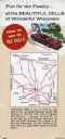
| Date: | |
|---|---|
| Description: | Back fold of a Wisconsin Dells promotional brochure featuring a simplified Wisconsin highway map with directions to the Dells, and a drawing of a family dr... |
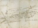
| Date: | |
|---|---|
| Description: | Hand-drawn map including the Clinch River and Clinch mountain range. The Clinch River rises in Southwest Virginia near Tazewell, VA and flows southwest thr... |

| Date: | |
|---|---|
| Description: | Hand-drawn map of the area at the time of Pilgrim landing, drawn by Charles Blaskowikz. Includes commemorative historical notes. |
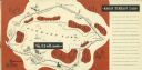
| Date: | 1951 |
|---|---|
| Description: | A drawing of the 5.3 mile race course around Elkhart Lake. Page 12 and 13 of the official program from Elkhart Lake Road Race. The race took place on Sunda... |

| Date: | 1887 |
|---|---|
| Description: | A bird's-eye map of Menekaune, Menominee and Marinette. |

| Date: | |
|---|---|
| Description: | Wisconsin promotional decal with a map of the state, with many cities marked and drawings of some Wisconsin icons: cheese, cows, deer, beer, Wisconsin Dell... |

| Date: | |
|---|---|
| Description: | Prehistoric Indian earthworks on the middle fork of the Duck River. |

| Date: | 1806 |
|---|---|
| Description: | Prehistoric Indian fortification on Hurricane Creek. |

| Date: | |
|---|---|
| Description: | Ink and watercolor of prehistoric mounds near the mouth of Haigs Creek and the Scioto River. |

| Date: | 07 1941 |
|---|---|
| Description: | Advertising proof for International trucks, featuring color illustrations of a truck and the United States, largely in red, white and blue. Includes the te... |

| Date: | 02 1823 |
|---|---|
| Description: | A map featuring the North American expedition from Pittsburgh to the Rocky Mountains led by Edwin James. |

| Date: | 1932 |
|---|---|
| Description: | Map of the Middle East accompanying an article on International's involvement in building the Iraq Pipe Line. Headline text on the page reads: "Internation... |

| Date: | 1952 |
|---|---|
| Description: | Map of the barley-growing regions of North America, published by the Rahr Malting Company, Manitowoc, Wisconsin, 1952. |

| Date: | |
|---|---|
| Description: | Back, front, and inside front cover of the menu from The Restaurant at Baron's department store, with "A Historical Map of Madison" focusing on the isthmus... |

| Date: | |
|---|---|
| Description: | Front and back covers of the Mortons Surf Club menu, with a black on blue grid of Chicago streets from Lake Michigan to Vincennes Avenue, and E. 45th to E.... |

| Date: | 1953 |
|---|---|
| Description: | Front and back of one-page menu from the Scandia Restaurant, with a whimsical cartoon map rendering by Hakon Mielche of the Scandinavian countries and the ... |

| Date: | 07 21 1951 |
|---|---|
| Description: | Luncheon menu for the S.S. Argentina, with a map of Argentina with spot illustrations for the provinces and featured products or symbols, the coat o... |
If you didn't find the material you searched for, our Library Reference Staff can help.
Call our reference desk at 608-264-6535 or email us at:
