| Date: | 1920 |
|---|---|
| Description: | Calumet Harbor on Lake Winnebago. On the left is a map, and on the right are two images, one captioned: "Calumet Harbor". |

| Date: | 1917 |
|---|---|
| Description: | The Lake Forest community plan, a model community that was planned for the site where the University of Wisconsin Arboretum now stands. |

| Date: | |
|---|---|
| Description: | Hand-drawn map of the area at the time of Pilgrim landing, drawn by Charles Blaskowikz. Includes commemorative historical notes. |

| Date: | 1887 |
|---|---|
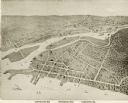
| Description: | A bird's-eye map of Menekaune, Menominee and Marinette. |

| Date: | 1925 |
|---|---|
| Description: | Map of northern Africa with the border between Algeria and Tunisia drawn in red. Caption reads: "199A — (L61208) Map Series 2 The Eastern Barbary States." |
If you didn't find the material you searched for, our Library Reference Staff can help.
Call our reference desk at 608-264-6535 or email us at: