 Filter: Categories of Wisconsin Historical Images
Filter: Subject of Maps
Filter: Subject of water
Filter: Creator Name of Unknown
Filter: Categories of Wisconsin Historical Images
Filter: Subject of Maps
Filter: Subject of water
Filter: Creator Name of Unknown

| Date: | 1930 |
|---|---|
| Description: | Page 8 of the 1930 schedule is a map of the routes of the Goodrich Steamship Lines in Lake Michigan and Lake Huron. |

| Date: | 1780 |
|---|---|
| Description: | Hand-drawn plan for the layout of the town of Clarksville, bordering Mayfield Creek and Liberty Creek. Fort Jefferson is shown between the townsite and the... |

| Date: | 1905 |
|---|---|
| Description: | Bird's-eye view of Manitowoc on the shores of Lake Michigan. A map of the northeastern part of the United States at the top indicates Manitowoc's location ... |

| Date: | 1836 |
|---|---|
| Description: | The map of Wisconsin City on the Wisconsin River. |

| Date: | 1920 |
|---|---|
| Description: | Calumet Harbor on Lake Winnebago. On the left is a map, and on the right are two images, one captioned: "Calumet Harbor". |

| Date: | 1910 |
|---|---|
| Description: | Aerial view of some of the 26 lakes known collectively as the Chain O' Lakes. Caption reads: "Aeroplane View of Chain O'Lakes, Waupaca, Wis." |

| Date: | 1917 |
|---|---|
| Description: | The Lake Forest community plan, a model community that was planned for the site where the University of Wisconsin Arboretum now stands. |

| Date: | 1904 |
|---|---|
| Description: | A map showing the design for a park fronting on Lake Monona Bay. (Now called Brittingham Park) taken from between pages 44 & 45 of the 1905 Madison Park a... |

| Date: | 1855 |
|---|---|
| Description: | Fox-Wisconsin portage and canal map, when the canal was not yet built. From a map in the office of the city clerk at Portage. "The old trail, the location ... |

| Date: | 1959 |
|---|---|
| Description: | University of Wisconsin-Madison campus. Numbers in circles identify buildings across campus with the building index. Black arrows point out important infor... |

| Date: | |
|---|---|
| Description: | Hand-drawn map of the area at the time of Pilgrim landing, drawn by Charles Blaskowikz. Includes commemorative historical notes. |

| Date: | 1887 |
|---|---|
| Description: | A bird's-eye map of Menekaune, Menominee and Marinette. |

| Date: | |
|---|---|
| Description: | Wisconsin promotional decal with a map of the state, with many cities marked and drawings of some Wisconsin icons: cheese, cows, deer, beer, Wisconsin Dell... |

| Date: | 02 1823 |
|---|---|
| Description: | A map featuring the North American expedition from Pittsburgh to the Rocky Mountains led by Edwin James. |

| Date: | |
|---|---|
| Description: | Front and back covers of the Mortons Surf Club menu, with a black on blue grid of Chicago streets from Lake Michigan to Vincennes Avenue, and E. 45th to E.... |

| Date: | 1953 |
|---|---|
| Description: | Front and back of one-page menu from the Scandia Restaurant, with a whimsical cartoon map rendering by Hakon Mielche of the Scandinavian countries and the ... |

| Date: | |
|---|---|
| Description: | Exterior of the menu for Paul's Cafe, with a bird's-eye view map of "Washburn's Natural Deep Water Land Locked Harbor," Chequamegon Bay, and the Apostle Is... |
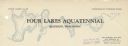
| Date: | |
|---|---|
| Description: | Letterhead of the Four Lakes Aquatennial, sponsored by the Four Lakes Club and the Veterans of Foreign Wars, with a background illustration of the chain of... |

| Date: | 04 15 1915 |
|---|---|
| Description: | A sketch of Little Lake Butte des Morts and the surrounding area, including Neenah and Menasha. |
If you didn't find the material you searched for, our Library Reference Staff can help.
Call our reference desk at 608-264-6535 or email us at:
