 Filter: Categories of Wisconsin Historical Images
Filter: Subject of Maps
Filter: Subject of water
Filter: Type of Photograph
Filter: Categories of Wisconsin Historical Images
Filter: Subject of Maps
Filter: Subject of water
Filter: Type of Photograph

| Date: | 1920 |
|---|---|
| Description: | Calumet Harbor on Lake Winnebago. On the left is a map, and on the right are two images, one captioned: "Calumet Harbor". |

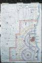
| Date: | 1917 |
|---|---|
| Description: | The Lake Forest community plan, a model community that was planned for the site where the University of Wisconsin Arboretum now stands. |
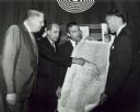
| Date: | 05 1966 |
|---|---|
| Description: | Gaylord Nelson points to a map of the Wolf River, as John Race, Stewart Udall, and Henry Reuss look on. |

| Date: | |
|---|---|
| Description: | Hand-drawn map of the area at the time of Pilgrim landing, drawn by Charles Blaskowikz. Includes commemorative historical notes. |

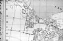
| Date: | 1887 |
|---|---|
| Description: | A bird's-eye map of Menekaune, Menominee and Marinette. |
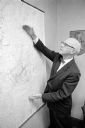
| Date: | 08 13 1965 |
|---|---|
| Description: | H.O. Lord, Madison Metropolitan Sewerage District chief engineer, outlining the existing sewerage district on a map. Lord is trying to educate the public c... |

| Date: | 1925 |
|---|---|
| Description: | Map of northern Africa with the border between Algeria and Tunisia drawn in red. Caption reads: "199A — (L61208) Map Series 2 The Eastern Barbary States." |
| Date: | 06 1960 |
|---|---|
| Description: | Photograph of street map of the Village of Shorewood Hills and Blackhawk Country Club. Lake Mendota is at the top of the map. |
| Date: | 1960 |
|---|---|
| Description: | Map showing the probable blast radius of a 20 megaton bomb on Milwaukee. The map also shows existing hospitals in the area, including outside Milwaukee Cou... |

| Date: | 1962 |
|---|---|
| Description: | Map of the city of Nancy, France. The IH Branch and a warehouse are circled. |

| Date: | 1962 |
|---|---|
| Description: | Title reads: "Plan de Ris-Orangis, Seine et Oise." The office or factory is indicated by a black circle. |

| Date: | 1962 |
|---|---|
| Description: | Map of the location of the office or factory, which is indicated by a black circle. |

| Date: | 1962 |
|---|---|
| Description: | Map of the location of the office or factory, which is indicated by a black circle. |
If you didn't find the material you searched for, our Library Reference Staff can help.
Call our reference desk at 608-264-6535 or email us at: