 Filter: Categories of Wisconsin Historical Images
Filter: Subject of Maps
Filter: Subject of transportation
Filter: Categories of Wisconsin Historical Images
Filter: Subject of Maps
Filter: Subject of transportation
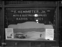
| Date: | 02 04 1929 |
|---|---|
| Description: | A display window for the "F. HEMMETER, JR. AUTO & ELECTRICAL SUPPLIES RADIOS - TIRES" showing a scale model diorama of an International truck and two men i... |

| Date: | 1952 |
|---|---|
| Description: | Map of the barley-growing regions of North America, published by the Rahr Malting Company, Manitowoc, Wisconsin, 1952. |

| Date: | 1962 |
|---|---|
| Description: | Two men speak across the service counter at Mt. Victory truck stop. Several posters and a map hang on the wall, and a cash register sits on the counter. |

| Date: | 1962 |
|---|---|
| Description: | Three men, probably truck drivers, gather at the service counter at the Mt. Victory truck stop. |

| Date: | |
|---|---|
| Description: | Back, front, and inside front cover of the menu from The Restaurant at Baron's department store, with "A Historical Map of Madison" focusing on the isthmus... |

| Date: | 06 08 1960 |
|---|---|
| Description: | Blueprint plat of Sunset Hills sub-division. |

| Date: | 08 08 1973 |
|---|---|
| Description: | At a press conference northern representatives joined together to press their respective states to use newly appropriated funds to improve U.S. Highway 2 f... |

| Date: | |
|---|---|
| Description: | Map and advertisement for the Casa del Norte Tea Rooms, with a grid of several blocks in downtown Duluth highlighting the tea rooms as well as other notabl... |
| Date: | 03 26 1944 |
|---|---|
| Description: | Front cover and menu listing from the Villa Ferrovieri in Italy with the Chicago Milwaukee St. Paul & Pacific (CMSP&P) logo printed in red ink on the cover... |

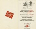
| Date: | |
|---|---|
| Description: | Front and back covers of the Mortons Surf Club menu, with a black on blue grid of Chicago streets from Lake Michigan to Vincennes Avenue, and E. 45th to E.... |

| Date: | 1953 |
|---|---|
| Description: | Front and back of one-page menu from the Scandia Restaurant, with a whimsical cartoon map rendering by Hakon Mielche of the Scandinavian countries and the ... |

| Date: | 07 21 1951 |
|---|---|
| Description: | Luncheon menu for the S.S. Argentina, with a map of Argentina with spot illustrations for the provinces and featured products or symbols, the coat o... |

| Date: | 1902 |
|---|---|
| Description: | Interior, with two men, of a small office, very likely a railroad company office. Maps are on the wall, and rolled up on a shelf near the ceiling. |
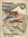
| Date: | 1900 |
|---|---|
| Description: | Catalog cover featuring an illustration of an Empire Drill on a map of the northeast United States. A railroad train is traveling east to west from Albany ... |
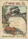
| Date: | 1901 |
|---|---|
| Description: | Catalog cover with the title: "The Three Greatest Empires," features an illustration of an Empire Drill in the foreground, and in the background a train tr... |

| Date: | 07 01 1954 |
|---|---|
| Description: | Two young people are examining a wall chart depicting traffic lanes, cross walks, and intersections. There are movable adhesive rectangles representing car... |
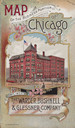
| Date: | 1893 |
|---|---|
| Description: | Front cover of a brochure for Champion Mowers and Binders. Features a color illustration of the office building of the Warder, Bushnell and Glessner Compan... |

| Date: | 1966 |
|---|---|
| Description: | A colored map depiction of Door County, Wisconsin, with pictorial highlights, titled: "Door County — Wisconsin's Air Conditioned Peninsula Playground." |

| Date: | 1950 |
|---|---|
| Description: | Inside spread illustration of the world, with a legend indicating: Subsidiary Company, Branch of Subsidiary, Representative, Works, and Distributor. |
If you didn't find the material you searched for, our Library Reference Staff can help.
Call our reference desk at 608-264-6535 or email us at:
