 Filter: Categories of Wisconsin Historical Images
Filter: Subject of Maps
Filter: Subject of transportation
Filter: Type of Drawing
Filter: Categories of Wisconsin Historical Images
Filter: Subject of Maps
Filter: Subject of transportation
Filter: Type of Drawing

| Date: | 1855 |
|---|---|
| Description: | Fox-Wisconsin portage and canal map, when the canal was not yet built. From a map in the office of the city clerk at Portage. "The old trail, the location ... |
| Date: | |
|---|---|
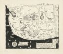
| Description: | A pen drawing, in the style of a birds-eye map, of Frank and Delia King's estate Folly Farm in Kissimee, Florida. |

| Date: | 06 08 1960 |
|---|---|
| Description: | Blueprint plat of Sunset Hills sub-division. |
| Date: | |
|---|---|
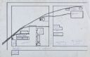
| Description: | Line drawing on tissue paper showing the layout of the Gisholt plant buildings over two blocks at East Washington and Baldwin Streets. Shows streets and ra... |
| Date: | 1910 |
|---|---|
| Description: | Carl Greene's drawing of a map of The Gang's trip to Winton, titled "We drive to Winton." This map shows a road currently known as the Thirteen Corners Roa... |

| Date: | 1838 |
|---|---|
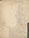
| Description: | Drawing of Shullsburg. There is a numbered key on the left that reads, at top: "Explanation. Nos. Denote present Site." Streets are named on the map and ma... |
| Date: | 1929 |
|---|---|
| Description: | An unsigned, hand-drawn map of properties owned by members of the Brumder family on the northwest shore of Pine Lake in 1929. Named Villa Henrietta, the pr... |

| Date: | 1867 |
|---|---|
| Description: | A map and profile map of the railroad line from Omaha to San Francisco. |

| Date: | 11 03 1903 |
|---|---|
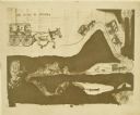
| Description: | A drawing of a group of burial mounds in Linden Valley. Text on back reads: "These mounds lie at the narrow mouth of Linden Valley on the east side of the ... |
If you didn't find the material you searched for, our Library Reference Staff can help.
Call our reference desk at 608-264-6535 or email us at:
