 Filter: Categories of Wisconsin Historical Images
Filter: Subject of Maps
Filter: Subject of municipal services
Filter: Categories of Wisconsin Historical Images
Filter: Subject of Maps
Filter: Subject of municipal services
| Date: | |
|---|---|
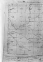
| Description: | Map, "Township No. 22 North, of Range No. 5 West of (?)," surveyed in 1846 and 1853. |

| Date: | 11 11 1959 |
|---|---|
| Description: | Portrait of Dane County highway commissioner, Ray R. Swann. |

| Date: | 12 1912 |
|---|---|
| Description: | Sanborn map of Sun Prairie, which includes an index and information about water facilities and the fire department. Includes a small inset map of the State... |
If you didn't find the material you searched for, our Library Reference Staff can help.
Call our reference desk at 608-264-6535 or email us at: