Filter: Categories of Wisconsin Historical Images
Filter: Subject of Maps
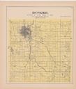
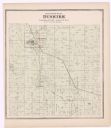
Filter: County of Dane
Filter: Categories of Wisconsin Historical Images
Filter: Subject of Maps
Filter: County of Dane
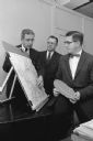
| Date: | 12 05 1958 |
|---|---|
| Description: | Lowell E. Frautschi, chairman of the research advisory committee of the Community Welfare Council (left), confers with Leonard Pederson of Oscar Mayer and ... |
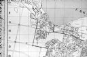
| Date: | 06 1960 |
|---|---|
| Description: | Photograph of street map of the Village of Shorewood Hills and Blackhawk Country Club. Lake Mendota is at the top of the map. |

| Date: | 09 27 1960 |
|---|---|
| Description: | Members of the Madison Chamber of Commerce staff and board show off a new brochure promoting the city. The brochure includes sections on the State Capitol,... |

| Date: | 11 09 1960 |
|---|---|
| Description: | Chet Bible, owner of Madison Mobile Homes along the Madison Beltline, points to his property on a map at a hearing held in the City-County building by the ... |
| Date: | 11 09 1960 |
|---|---|
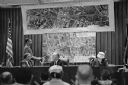
| Description: | A display to illustrate proposed improvements to the Madison Beltline highway at a hearing in the City-County Building by the State Highway Commission. |

| Date: | 1957 |
|---|---|
| Description: | Two children are standing and looking at an exhibit that features tools, a map, and some text. Caption reads: "Visitors in the pioneer gallery of the State... |

| Date: | 04 1960 |
|---|---|
| Description: | Walter E. Scott views a display arranged by Harold F. Williams showing the locations of Wisconsin members of the Wisconsin Academy of Sciences Arts and Let... |
| Date: | 1954 |
|---|---|
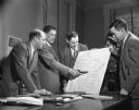
| Description: | Four men are standing around a desk looking at a map of Wisconsin marked with the county borders. Clifford Lord is pointing at the map with a tobaco pipe. ... |

| Date: | |
|---|---|
| Description: | Eight man sitting in a room looking at a map written on a chalkboard with symbols. One of the men is writing on the chalkboard. Caption reads: "Madison, Wi... |
If you didn't find the material you searched for, our Library Reference Staff can help.
Call our reference desk at 608-264-6535 or email us at: