 Filter: Categories of Wisconsin Historical Images
Filter: Subject of Maps
Filter: County of Dane
Filter: Type of Drawing
Filter: Categories of Wisconsin Historical Images
Filter: Subject of Maps
Filter: County of Dane
Filter: Type of Drawing

| Date: | 07 1838 |
|---|---|
| Description: | A map diagram of Indian effigy mounds seven miles east of Blue Mounds in the Wisconsin Territory. |
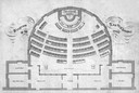
| Date: | 1860 |
|---|---|
| Description: | Floor plan and seating chart for the Assembly for their first meeting in the East Wing of new Wisconsin State Capitol building. After the completion of th... |

| Date: | 06 08 1960 |
|---|---|
| Description: | Blueprint plat of Sunset Hills sub-division. |
If you didn't find the material you searched for, our Library Reference Staff can help.
Call our reference desk at 608-264-6535 or email us at: