 Filter: Categories of Wisconsin Historical Images
Filter: Subject of Maps
Filter: Type of Drawing
Filter: Categories of Wisconsin Historical Images
Filter: Subject of Maps
Filter: Type of Drawing
| Date: | |
|---|---|
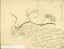
| Description: | Drawn map of Blackstock's Plantation battlefield from the Sumter Papers. |
| Date: | |
|---|---|
| Description: | Drawn map of the Fish Damn Ford battlefield from the Thomas Sumter Papers. |
| Date: | |
|---|---|
| Description: | Drawn map of Blackstock's Plantation battlefield from the Thomas Sumter Papers. |

| Date: | 1855 |
|---|---|
| Description: | Fox-Wisconsin portage and canal map, when the canal was not yet built. From a map in the office of the city clerk at Portage. "The old trail, the location ... |
| Date: | 07 15 1927 |
|---|---|
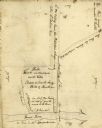
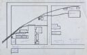
| Description: | Survey and development plan of the home grounds area of Mr. and Mrs. George S. Parker, drawn in red, black, and brown ink. |

| Date: | 1837 |
|---|---|
| Description: | Copy of N.F. Hyer's original map of Aztalan as published in the Milwaukee Advertiser, February 25, 1837. |
| Date: | |
|---|---|
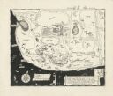
| Description: | A pen drawing, in the style of a birds-eye map, of Frank and Delia King's estate Folly Farm in Kissimee, Florida. |
| Date: | |
|---|---|
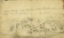
| Description: | A rough sketch of Camp Judas, the 12th Regiment's first bivouac under Colonel George E. Bryant. |

| Date: | |
|---|---|
| Description: | Prehistoric Indian earthworks on the middle fork of the Duck River. |

| Date: | 1806 |
|---|---|
| Description: | Prehistoric Indian fortification on Hurricane Creek. |

| Date: | |
|---|---|
| Description: | A plat of Mammoth Cave with detailed descriptive annotations. |

| Date: | |
|---|---|
| Description: | Map of prehistoric mounds near the Big Kanawha River. |

| Date: | |
|---|---|
| Description: | A map of the prehistoric fort at Circleville with annotations by Daniel Drake. |

| Date: | 06 08 1960 |
|---|---|
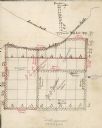
| Description: | Blueprint plat of Sunset Hills sub-division. |

| Date: | 1828 |
|---|---|
| Description: | Drawing by Increase Lapham showing the geological profile of the land between Utica and Knob Creek, Kentucky at a scale of 1/2 inch to a mile. |

| Date: | 04 15 1915 |
|---|---|
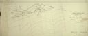
| Description: | A sketch of Little Lake Butte des Morts and the surrounding area, including Neenah and Menasha. |
| Date: | |
|---|---|
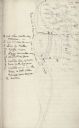
| Description: | Hand-drawn map detailing acreage of land leased by G.E. Lemmon and J. Walker. |
| Date: | |
|---|---|
| Description: | Line drawing on tissue paper showing the layout of the Gisholt plant buildings over two blocks at East Washington and Baldwin Streets. Shows streets and ra... |
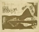
| Date: | 1910 |
|---|---|
| Description: | Carl Greene's drawing of a map of The Gang's trip to Winton, titled "We drive to Winton." This map shows a road currently known as the Thirteen Corners Roa... |
If you didn't find the material you searched for, our Library Reference Staff can help.
Call our reference desk at 608-264-6535 or email us at:
