Filter: Categories of Wisconsin Historical Images
Filter: Subject of Maps
Filter: Type of Drawing
Filter: Categories of Wisconsin Historical Images
Filter: Subject of Maps
Filter: Type of Drawing

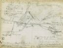
| Date: | 07 1838 |
|---|---|
| Description: | A map diagram of Indian effigy mounds seven miles east of Blue Mounds in the Wisconsin Territory. |
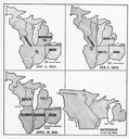
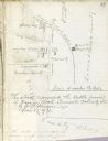
| Date: | 01 11 1805 |
|---|---|
| Description: | Four map illustrations showing the political subdivisions of the Northwest Territory from 1805 through 1834. |

| Date: | 1780 |
|---|---|
| Description: | Hand-drawn plan for the layout of the town of Clarksville, bordering Mayfield Creek and Liberty Creek. Fort Jefferson is shown between the townsite and the... |

| Date: | 1780 |
|---|---|
| Description: | Plan for layout of 150,00 acres which make up Clark's Illinois Grant. |

| Date: | 1860 |
|---|---|
| Description: | Floor plan and seating chart for the Assembly for their first meeting in the East Wing of new Wisconsin State Capitol building. After the completion of th... |

| Date: | 08 24 1876 |
|---|---|
| Description: | Hand-drawn plan of the battleground of Huycks. |

| Date: | 03 26 1876 |
|---|---|
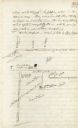
| Description: | Hand-drawn map showing the place of Hook's defeat in York County in South Carolina. |
| Date: | |
|---|---|
| Description: | Plat map of Mammoth Cave. A note on the map reads: "Mrs. Campbell conjectures that this is a saltpeter cave in Green River, Kentucky. The mummy found in it... |

| Date: | |
|---|---|
| Description: | A very vague sketch of a map of North Racine, Wisconsin. |
| Date: | |
|---|---|
| Description: | A simple sketch of a section of Arkansas, showing the Arkansas River, White River and Helena, Arkansas. |

| Date: | 08 10 1862 |
|---|---|
| Description: | A hand-drawn map of the Battle of Wilson's Creek, Springfield, Missouri. Other notes and locations include: "Lyon was killed instantly while heading his tr... |

| Date: | |
|---|---|
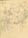
| Description: | A hand-drawn map of the state of Missouri with a separate drawing of a map showing Forts Henry and Donelson. The Missouri map includes Jefferson City and s... |
| Date: | 04 06 1862 |
|---|---|
| Description: | A hand-drawn map of the Battle of Shiloh, Pittsburg Landing, Tennessee. Additional Notes include "Reserve Artillery," "Hospital," "Owl Creek," and "Snake C... |
| Date: | |
|---|---|
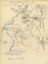
| Description: | A hand-drawn map of Tennessee and surrounding states. Some cities located include: St. Louis, Louisville, Cinncinati, Nashville, Murfreesboro, Knoxville, T... |
| Date: | |
|---|---|
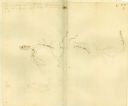
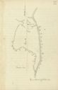
| Description: | Drawn map of the Catawba River, fishing creek, and surrounding landscape from the Sumter Papers. |
| Date: | |
|---|---|
| Description: | Drawn map of Landsford, South Carolina, from Thomas Sumter Papers. |
| Date: | |
|---|---|
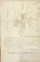
| Description: | Drawn map of the Hanging Rock Battlefield in the Thomas Sumter Papers. |
| Date: | |
|---|---|
| Description: | Drawn map of Hanging Rock Battlefield from the Thomas Sumter Papers. |
If you didn't find the material you searched for, our Library Reference Staff can help.
Call our reference desk at 608-264-6535 or email us at: