 Filter: Categories of Wisconsin Historical Images
Filter: Subject of Lumber trade
Filter: Subject of transportation
Filter: Year of 1800-1899
Filter: Year of 1890-1899
Filter: Categories of Wisconsin Historical Images
Filter: Subject of Lumber trade
Filter: Subject of transportation
Filter: Year of 1800-1899
Filter: Year of 1890-1899

| Date: | 1891 |
|---|---|
| Description: | Bird's-eye view of Eau Claire. |

| Date: | 1896 |
|---|---|
| Description: | Bird's-eye view of Washburn, with twenty vignettes around side, water in foreground with docks and lumber corral. Thirty-three locations identified in key ... |
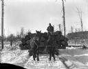
| Date: | 1899 |
|---|---|
| Description: | Front view of a man holding the reins of two horses hitched to a sled loaded with logs on a snowy path in or near Vinette's logging camp. |
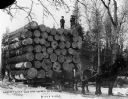
| Date: | 1895 |
|---|---|
| Description: | Two men stand at Hein's Lumber Camp atop a load of logs on a sled to which is hitched four horses, claimed to be the largest load of logs ever hauled by fo... |
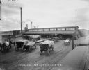
| Date: | 1899 |
|---|---|
| Description: | Several wagon loads of lumber stand in the yard of a planing mill. |

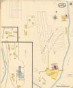
| Date: | 09 1891 |
|---|---|
| Description: | Sanborn map of Hurley, featuring the Village of Gile and the Montreal River Lumber Company. |

| Date: | 1898 |
|---|---|
| Description: | Sanborn map of Hurley featuring the Village of Gile. |

| Date: | 06 1890 |
|---|---|
| Description: | This map shows building use, railroads, tramways, lumber yards, roads, watchman’s stations, and steam pipes. Also included is text about buildings, Clapp a... |

| Date: | 1892 |
|---|---|
| Description: | A Sanborn map of St. Louis, which is six miles southwest of South Superior. |
| Date: | 05 1894 |
|---|---|
| Description: | Sheet 5 of an Sanborn map of Onalaska featuring the Island Lumber Company. |

| Date: | 10 1894 |
|---|---|
| Description: | A Sanborn Fire Insurance Map of Waunakee. |

| Date: | 1892 |
|---|---|
| Description: | A Sanborn fire insurance map of Sauk City which was drawn up in 1892. |
If you didn't find the material you searched for, our Library Reference Staff can help.
Call our reference desk at 608-264-6535 or email us at:

