 Filter: Categories of Wisconsin Historical Images
Filter: Subject of Lumber trade
Filter: Subject of transportation
Filter: Subject of water
Filter: Categories of Wisconsin Historical Images
Filter: Subject of Lumber trade
Filter: Subject of transportation
Filter: Subject of water

| Date: | 02 03 2011 |
|---|---|
| Description: | Underwater overhead view of the schooner Home taken from the starboard side near the stern. Two underwater archeologists are swimming over the site ... |

| Date: | 02 03 2011 |
|---|---|
| Description: | Underwater overhead view of the collision damage and the deck of the schooner Home. Two underwater archeologists are surveying the site. |

| Date: | 1912 |
|---|---|
| Description: | Marinette plat map, Township 37 N., Range 19 E. |

| Date: | 1912 |
|---|---|
| Description: | Marinette County, Township 37 N., Range 20 E. |

| Date: | 1912 |
|---|---|
| Description: | Marinette County, Fract. Township 36 N., Ranges 21 and 22 E. |

| Date: | 05 01 2014 |
|---|---|
| Description: | Underwater view of the bow of the Rouse Simmons with a Christmas tree placed on it. Local divers, every year (typically on the date the Rouse Sim... |

| Date: | |
|---|---|
| Description: | View across water towards the lumber steamer Chas. B. Packard docked with a load of lumber. Several crew members are standing on the deck, and men a... |

| Date: | 1892 |
|---|---|
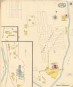
| Description: | A Sanborn map of St. Louis, which is six miles southwest of South Superior. |
| Date: | 05 1894 |
|---|---|
| Description: | Sheet 5 of an Sanborn map of Onalaska featuring the Island Lumber Company. |

| Date: | 1972 |
|---|---|
| Description: | A topographic map of the Blackwell quadrangle. |

| Date: | 1901 |
|---|---|
| Description: | A Sanborn map of Tomahawk featuring the Bay Mill Company's lumber yard. |

| Date: | 1901 |
|---|---|
| Description: | A plat map of Marathon county, 28 township, north range, 7 east. |

| Date: | 1901 |
|---|---|
| Description: | A plat map of Marathon county, township 28, north range, 8 east. |
| Date: | 1910 |
|---|---|
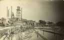
| Description: | View from the Oconto River of the Holt Lumber Company. A man is standing on a log boom and guiding logs to the sawmill. Writing on the postcard reads: "Hol... |

| Date: | 1911 |
|---|---|
| Description: | Map of states in the United States, as well as inset maps of Russia, France, Germany and Sweden. At bottom right is a key for the map that includes: a numb... |

| Date: | 2005 |
|---|---|
| Description: | Underwater view of the port side of the wreck of the schooner Home. |
| Date: | |
|---|---|
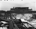
| Description: | View across water towards a large building above a waterfall. Ice is coating the sides of the river. A bridge is in the foreground on the left. Railroad ca... |
If you didn't find the material you searched for, our Library Reference Staff can help.
Call our reference desk at 608-264-6535 or email us at:


