 Filter: Categories of Wisconsin Historical Images
Filter: Subject of Lumber trade
Filter: Subject of transportation
Filter: Subject of water
Filter: Categories of Wisconsin Historical Images
Filter: Subject of Lumber trade
Filter: Subject of transportation
Filter: Subject of water

| Date: | 1925 |
|---|---|
| Description: | Shows buildings, piers, winter and summer levels, and resort lands. Depths shown by isolines. Relief shown by contours. From the E.P. Sherry papers relatin... |

| Date: | 1889 |
|---|---|
| Description: | Shows city limits, railroads, mills, schools, cemeteries, dams, parks, lumber yards, log canals, log reservoir, Chippewa River, Eau Claire River, and Half ... |

| Date: | 1908 |
|---|---|
| Description: | Title at top: "G.F. Sanborn Company Timber and Farming Lands." Map shows acreages, roads, railroads, and swamps in parts of Vilas and Oneida counties. |

| Date: | 09 1891 |
|---|---|
| Description: | Sanborn map of Hurley, featuring the Village of Gile and the Montreal River Lumber Company. |

| Date: | 1898 |
|---|---|
| Description: | Sanborn map of Hurley featuring the Village of Gile. |
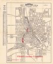
| Date: | 1924 |
|---|---|
| Description: | This map of Janesville was distrusted by the Fifield Lumber Company and features labeled streets, the Rock River, and Fifield Lumber Company buildings in r... |
| Date: | 1910 |
|---|---|
| Description: | Colorized postcard of logs floating in river, looking east between falls and railroad bridge. In the upper right corner is a large number of logging pylons... |
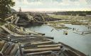
| Date: | 1910 |
|---|---|
| Description: | Elevated view looking east and upstream from the shoreline towards the wide Chippewa River. The water level is nearly up to the railroad tracks in the fore... |

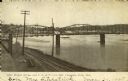
| Date: | 1925 |
|---|---|
| Description: | View from bridge or boat railing of piles of lumber in the Paine Lumber Company yards on the banks of the Fox River. There is a boat house on the left shor... |

| Date: | 06 1890 |
|---|---|
| Description: | This map shows building use, railroads, tramways, lumber yards, roads, watchman’s stations, and steam pipes. Also included is text about buildings, Clapp a... |

| Date: | 06 1923 |
|---|---|
| Description: | Sanborn map of Ashland, which includes Chequamegon Bay. |

| Date: | 1982 |
|---|---|
| Description: | This standard U.S.G.S. topographic map was annotated by civil engineer and railroad historian James P. Kaysen to show the location of existing and defunct ... |

| Date: | 2008 |
|---|---|
| Description: | Underwater view of the stern of the schooner Home resting on the bottom of Lake Michigan. One of the masts is broken and is bending over the port si... |

| Date: | 06 12 2008 |
|---|---|
| Description: | Underwater view of the bow of the schooner Home. The port anchor is hanging along the port side of the ship. The bowsprit is laying on the lake bed ... |

| Date: | 06 12 2008 |
|---|---|
| Description: | Underwater view of the deck of the schooner Home, taken from the port side near the bow. The structure in the center of the deck is the centerboard ... |

| Date: | 06 22 2015 |
|---|---|
| Description: | Underwater view of the starboard side of the bow of the schooner Home, the site of the collision damage that sank the ship. The sampson post and win... |

| Date: | 09 28 2005 |
|---|---|
| Description: | Underwater view of the port anchor on the schooner Home. The anchor and chain are resting against the port side of the ship near the bow, partially ... |

| Date: | 06 02 2015 |
|---|---|
| Description: | Underwater view of the deck of the schooner Home, taken from the bow. |
If you didn't find the material you searched for, our Library Reference Staff can help.
Call our reference desk at 608-264-6535 or email us at:

