 Filter: Categories of Wisconsin Historical Images
Filter: Subject of Lumber trade
Filter: Subject of transportation
Filter: Subject of dams
Filter: Categories of Wisconsin Historical Images
Filter: Subject of Lumber trade
Filter: Subject of transportation
Filter: Subject of dams
| Date: | |
|---|---|
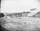
| Description: | Several men on a raft going over the dam at Munger's Mill. There is a railroad bridge in the background. |

| Date: | 12 21 1882 |
|---|---|
| Description: | Bird's-eye map of Kaukauna, from the Appleton Post Annual Review. |
| Date: | 1900 |
|---|---|
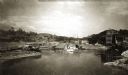
| Description: | View up the Eau Claire River from the Dewey Street Bridge. The view shows the dam and linen mill and the site of the lower sawmill (called the "steam mill"... |
| Date: | |
|---|---|
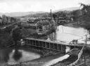
| Description: | Elevated view of the mill, dam, and railroad tracks, and forests surrounding the area. The lumber mill itself, with main building complex and smokestack is... |

| Date: | 1900 |
|---|---|
| Description: | Shows limits of drainage basin, dams, rapids, roads, and railroads in parts of Iron and Vilas Counties, Wisconsin. From the E.P. Sherry papers relating to ... |

| Date: | 1889 |
|---|---|
| Description: | Shows city limits, railroads, mills, schools, cemeteries, dams, parks, lumber yards, log canals, log reservoir, Chippewa River, Eau Claire River, and Half ... |
| Date: | |
|---|---|
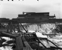
| Description: | View across water towards a large building above a waterfall. Ice is coating the sides of the river. A bridge is in the foreground on the left. Railroad ca... |
If you didn't find the material you searched for, our Library Reference Staff can help.
Call our reference desk at 608-264-6535 or email us at: