 Filter: Categories of Wisconsin Historical Images
Filter: Subject of Lumber trade
Filter: Type of Map or Atlas
Filter: Year of 1800-1899
Filter: Categories of Wisconsin Historical Images
Filter: Subject of Lumber trade
Filter: Type of Map or Atlas
Filter: Year of 1800-1899

| Date: | 1886 |
|---|---|
| Description: | Bird's-eye map of Washburn on Lake Superior. There is an inset of Washburn, Chequamagon and the Apostle Islands. |

| Date: | 1874 |
|---|---|
| Description: | Bird's-eye map of Chippewa Falls. |

| Date: | 1891 |
|---|---|
| Description: | Bird's-eye view of Eau Claire. |
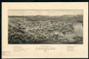
| Date: | 1881 |
|---|---|
| Description: | The county and city of Florence were named for Florence Hulst, the wife of an early settler. This view illustrates the two industries, mining and lumbering... |

| Date: | 12 21 1882 |
|---|---|
| Description: | Bird's-eye map of Kaukauna, from the Appleton Post Annual Review. |

| Date: | 1883 |
|---|---|
| Description: | Bird's-eye map of Marshfield, with one vignette. |

| Date: | 1871 |
|---|---|
| Description: | Birds eye map of New London depicts street names and street locations, houses, trees, the bridge, Wolf River, and the bayou. At the bottom of the map, a re... |

| Date: | 1879 |
|---|---|
| Description: | Bird's-eye map of Two Rivers. |

| Date: | 1896 |
|---|---|
| Description: | Bird's-eye view of Washburn, with twenty vignettes around side, water in foreground with docks and lumber corral. Thirty-three locations identified in key ... |

| Date: | 1885 |
|---|---|
| Description: | Fire insurance map of the McCormick Reaper Works, a factory of the McCormick Harvesting Machine Company. |

| Date: | 09 1884 |
|---|---|
| Description: | Sanborn map of Fort Atkinson including South Water and Milwaukee Streets. |

| Date: | 03 29 1888 |
|---|---|
| Description: | "Dated this 29th day of March AD 1888." Certifications on verso signed by: William Powrie, county surveyor -- Henry Sherry, landowner -- E.E. Paddock, not... |

| Date: | 1889 |
|---|---|
| Description: | Shows city limits, railroads, mills, schools, cemeteries, dams, parks, lumber yards, log canals, log reservoir, Chippewa River, Eau Claire River, and Half ... |

| Date: | 1800 |
|---|---|
| Description: | The map is ink and pencil on paper. Map shows the location of the Ashland Lumber Company as well as a portion of Ashland County. Portions of the map are in... |

| Date: | 09 1891 |
|---|---|
| Description: | Sanborn map of Hurley, featuring the Village of Gile and the Montreal River Lumber Company. |

| Date: | 1898 |
|---|---|
| Description: | Sanborn map of Hurley featuring the Village of Gile. |

| Date: | 06 1890 |
|---|---|
| Description: | This map shows building use, railroads, tramways, lumber yards, roads, watchman’s stations, and steam pipes. Also included is text about buildings, Clapp a... |

| Date: | 1892 |
|---|---|
| Description: | A Sanborn map of St. Louis, which is six miles southwest of South Superior. |
If you didn't find the material you searched for, our Library Reference Staff can help.
Call our reference desk at 608-264-6535 or email us at:

