 Filter: Categories of Wisconsin Historical Images
Filter: Subject of Lumber
Filter: Subject of transportation
Filter: Year of 1800-1899
Filter: County of Marathon
Filter: Categories of Wisconsin Historical Images
Filter: Subject of Lumber
Filter: Subject of transportation
Filter: Year of 1800-1899
Filter: County of Marathon
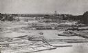
| Date: | 1866 |
|---|---|
| Description: | Elevated view taken from the extreme end of Clark's Saw and Planing Mill. An old flour mill can be seen behind the bridge, and to the extreme right are thr... |

| Date: | 1899 |
|---|---|
| Description: | This map is ink on tracing cloth and shows lot and block numbers and dimensions, streets, the high school park, and survey monuments. The map is oriented ... |
If you didn't find the material you searched for, our Library Reference Staff can help.
Call our reference desk at 608-264-6535 or email us at: