 Filter: Categories of Wisconsin Historical Images
Filter: Subject of Lumber
Filter: Subject of transportation
Filter: County of Iron
Filter: Categories of Wisconsin Historical Images
Filter: Subject of Lumber
Filter: Subject of transportation
Filter: County of Iron

| Date: | 1896 |
|---|---|
| Description: | A map of Iron County, Wisconsin, shows vacant Wisconsin Central Rail Road lands, settlers houses, land sold by Wisconsin Central R.R., schools, churches, s... |

| Date: | 1898 |
|---|---|
| Description: | A map of Iron County, Wisconsin, shows vacant Wisconsin Central Rail Road lands, settlers houses, land sold by Wisconsin Central R.R., schools, churches, s... |

| Date: | |
|---|---|
| Description: | Map of northern Iron County, Wisconsin, shows town sections and railroads in the towns of Saxon, Kimball, and Gurney. It also includes the area of the La P... |
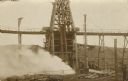
| Date: | 05 02 1910 |
|---|---|
| Description: | The postcard shows billowing smoke from the Hurley, Wisconsin Windsor mine shaft. Two men who were in the mine at the time lost their lives. A group of boy... |
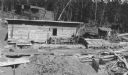
| Date: | 08 1937 |
|---|---|
| Description: | Lumber is stacked in three large piles behind a small wooden shed. There is machinery in front of the shed on the right, and what appears to be a saw pit o... |

| Date: | 1907 |
|---|---|
| Description: | Elevated view of Hurley, WI and nearby industrial sites (Scott & Howe Lumber Co. Mill, Ashland Mine). Inventory reads: "Looking west and a little south ove... |
If you didn't find the material you searched for, our Library Reference Staff can help.
Call our reference desk at 608-264-6535 or email us at: