 Filter: Categories of Wisconsin Historical Images
Filter: Subject of Logging
Filter: Subject of water
Filter: Subject of roads
Filter: Categories of Wisconsin Historical Images
Filter: Subject of Logging
Filter: Subject of water
Filter: Subject of roads

| Date: | 1870 |
|---|---|
| Description: | Bird's-eye map of Prairie du Sac. |
| Date: | |
|---|---|
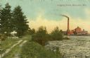
| Description: | Colorized view of a river full of logs, and a smokestack and factory in the distance. On the left is a dirt road and trees. Caption reads: "Logging Scene, ... |
| Date: | 1920 |
|---|---|
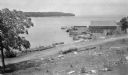
| Description: | View from hill looking down at a wood framed warehouse building on a pier with boats docked alongside. Near the warehouse are fish net drying reels. Wooded... |

| Date: | 1853 |
|---|---|
| Description: | This map shows camps, forts, logging camps, lakes, roads, railroads, the Wisconsin River, and Lac Du Flambeau Indian Reservation. Some points of interest a... |
If you didn't find the material you searched for, our Library Reference Staff can help.
Call our reference desk at 608-264-6535 or email us at:

