 Filter: Categories of Wisconsin Historical Images
Filter: Subject of Logging
Filter: Subject of water
Filter: Subject of railroads
Filter: Categories of Wisconsin Historical Images
Filter: Subject of Logging
Filter: Subject of water
Filter: Subject of railroads

| Date: | 1881 |
|---|---|
| Description: | A brochure with a map of Wisconsin that also includes information (in English, German, Norwegian, and Swedish) pertaining to the state, such as its timber ... |
| Date: | |
|---|---|
| Description: | We tend to forget that at the time of the destruction of the forests, an emergency situation existed. The need for lumber for the building up of the... |

| Date: | 1853 |
|---|---|
| Description: | This map shows camps, forts, logging camps, lakes, roads, railroads, the Wisconsin River, and Lac Du Flambeau Indian Reservation. Some points of interest a... |

| Date: | 1969 |
|---|---|
| Description: | This map shows ghost towns, Indian reservations, lakes, railroads, and rivers. Ghost towns are numbered and listed in a corresponding index. |
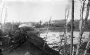
| Date: | |
|---|---|
| Description: | A view of logs transported by rail heading toward a group of buildings. A man is sitting on a stack of logs on the left. Other logs are floating in the wat... |
If you didn't find the material you searched for, our Library Reference Staff can help.
Call our reference desk at 608-264-6535 or email us at:

