 Filter: Categories of Wisconsin Historical Images
Filter: Subject of Logging
Filter: Subject of transportation
Filter: Subject of indian reservations
Filter: Categories of Wisconsin Historical Images
Filter: Subject of Logging
Filter: Subject of transportation
Filter: Subject of indian reservations

| Date: | 1853 |
|---|---|
| Description: | This map shows camps, forts, logging camps, lakes, roads, railroads, the Wisconsin River, and Lac Du Flambeau Indian Reservation. Some points of interest a... |

| Date: | 1969 |
|---|---|
| Description: | This map shows ghost towns, Indian reservations, lakes, railroads, and rivers. Ghost towns are numbered and listed in a corresponding index. |
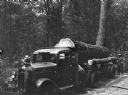
| Date: | 07 1936 |
|---|---|
| Description: | A large, white pine tree is loaded on the back of a truck, ready to be hauled from a Menominee Indian reservation to the Wisconsin State Fair. |
If you didn't find the material you searched for, our Library Reference Staff can help.
Call our reference desk at 608-264-6535 or email us at: