 Filter: Categories of Wisconsin Historical Images
Filter: Subject of Logging
Filter: Subject of lakes
Filter: Year of 1800-1899
Filter: Categories of Wisconsin Historical Images
Filter: Subject of Logging
Filter: Subject of lakes
Filter: Year of 1800-1899
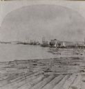
| Date: | 1871 |
|---|---|
| Description: | Stereograph of a sawmill area and Lake Winnebago in the foreground. The square building with the "cupola" was the Revere House. A manuscript notation, very... |

| Date: | 1881 |
|---|---|
| Description: | A brochure with a map of Wisconsin that also includes information (in English, German, Norwegian, and Swedish) pertaining to the state, such as its timber ... |

| Date: | 1853 |
|---|---|
| Description: | This map shows camps, forts, logging camps, lakes, roads, railroads, the Wisconsin River, and Lac Du Flambeau Indian Reservation. Some points of interest a... |
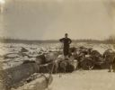
| Date: | 1890 |
|---|---|
| Description: | View of a man standing on a log among a large pile of logs spread out on the snow-covered ice of a lake. He is leaning on the handle of what may be a cant ... |
If you didn't find the material you searched for, our Library Reference Staff can help.
Call our reference desk at 608-264-6535 or email us at:
