 Filter: Categories of Wisconsin Historical Images
Filter: Subject of Locks (Hydraulic engineering)
Filter: Reproduction Rights of For Sale
Filter: Year of 1800-1899
Filter: Categories of Wisconsin Historical Images
Filter: Subject of Locks (Hydraulic engineering)
Filter: Reproduction Rights of For Sale
Filter: Year of 1800-1899
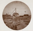
| Date: | 1897 |
|---|---|
| Description: | De Pere lock on the Fox River with a construction crew at work. This is the only wooden lock on the Fox River. |
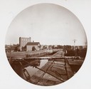
| Date: | 1897 |
|---|---|
| Description: | Locks near De Pere, the only wooden pier on the Fox River. |
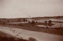
| Date: | 06 1898 |
|---|---|
| Description: | The Fox River seen from the hill behind the Catholic Church and looking toward the combined locks. In the distance is a paper mill. |
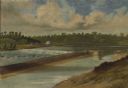
| Date: | 1856 |
|---|---|
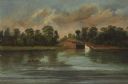
| Description: | "The second view at the Kakalin, from the north side of the river, shows the first or guard lock in the foreground and beyond the dam the large frame build... |
| Date: | 1856 |
|---|---|
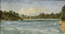
| Description: | "Three views in a short space show the peaceful appearance of what is now a busy paper mills center. The first, a double lock around which the village of C... |
| Date: | 1856 |
|---|---|
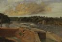
| Description: | "....The third view was twelve miles farther up the river [from De Pere], at Rapid Croche, on the border of the present Brown and Outagamie counties. It is... |
| Date: | 1856 |
|---|---|
| Description: | " . . . At Grand Chute stood the young settlement of Appleton. Although only a few years old, it already boasted a college, named, as was the village itsel... |

| Date: | 1873 |
|---|---|
| Description: | Engraved image of a lock and dam at Sault St. Marie. Two men are operating the sluice as ships are waiting on the opposite side of the lock. Another man is... |

| Date: | 08 17 1874 |
|---|---|
| Description: | This manuscript drawing provides a side elevation, plan, and perspective view for a proposed lock on the Fox River. |

| Date: | 1892 |
|---|---|
| Description: | This map shows the dams and locks of the Fox River between Neenah, in Winnebago County, Wisconsin, and Kaukauna, in Outagamie County. The cities and villag... |

| Date: | 1868 |
|---|---|
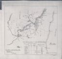
| Description: | Map showing the northern water routes between Mississippi River and Atlantic Ocean Relief shown by hachures. Includes Profile of the Erie Canal, table of ... |

| Date: | 1875 |
|---|---|
| Description: | This map, from G.K. Warren's 1876 Report on the transportation route along the Wisconsin and Fox Rivers in the State of Wisconsin between the Mississippi R... |

| Date: | 1857 |
|---|---|
| Description: | This map shows lot and block numbers, streets, railroad depots, locks, bridges, dams, canals, U.S. light house, college grounds, a steam boat landing, and ... |
| Date: | 1897 |
|---|---|
| Description: | This map shows the distances along Fox River, as well as adjacent lakes and railroads, between Green Bay and the Wisconsin River. Lake Michigan is on the f... |
If you didn't find the material you searched for, our Library Reference Staff can help.
Call our reference desk at 608-264-6535 or email us at: