 Filter: Categories of Wisconsin Historical Images
Filter: Subject of Loading docks
Filter: Subject of land use, rural
Filter: Categories of Wisconsin Historical Images
Filter: Subject of Loading docks
Filter: Subject of land use, rural
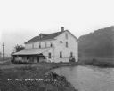
| Date: | 1925 |
|---|---|
| Description: | View along shoreline of a mill on a river. There is a man loading bags onto a cart at the front. There is a wooded hill on the right. |

| Date: | 1755 |
|---|---|
| Description: | Map of Virginia and parts of Maryland, North Carolina, and New Jersey. It shows borders, boundary lines, some Native American land, counties, cities, towns... |
If you didn't find the material you searched for, our Library Reference Staff can help.
Call our reference desk at 608-264-6535 or email us at: