Filter: Categories of Wisconsin Historical Images
Filter: Subject of Lighthouses
Filter: Year of 1800-1899
Filter: Year of 1890-1899
Filter: Categories of Wisconsin Historical Images
Filter: Subject of Lighthouses
Filter: Year of 1800-1899
Filter: Year of 1890-1899
| Date: | 1897 |
|---|---|
| Description: | Long view of the Minnesota Point lighthouse, built at the entrance to Superior Harbor. It is allegedly the first lighthouse at the head of Lake Superior. |

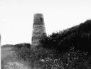
| Date: | 1890 |
|---|---|
| Description: | Second Long Tail Point lighthouse, built in 1859. |
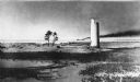
| Date: | 1890 |
|---|---|
| Description: | Long Tail lighthouse. Built in 1847-1848 and abandoned in 1859 when a new frame lighthouse was built nearby. |
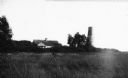
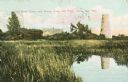
| Date: | 1898 |
|---|---|
| Description: | View across field towards the lighthouse and other buildings among trees. Caption reads: "Long Tail Point, Green Bay, Wis." |
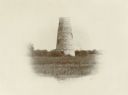
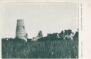
| Date: | 1898 |
|---|---|
| Description: | Caption reads: "Old Stone Tower and House, Long Tail Point, Green Bay, Wis." Water and a marshy area are in the foreground. |
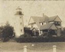
| Date: | 1895 |
|---|---|
| Description: | A chain and posts border the yard of the lighthouse, which is attached to a two-story house. |
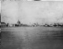
| Date: | 1893 |
|---|---|
| Description: | View of the Columbian Exposition grounds from Lake Michigan. |
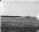
| Date: | 07 07 1898 |
|---|---|
| Description: | View across water of Sturgeon Bay. In the far distance are lighthouses, buildings, and barges along the shoreline. |

| Date: | 1896 |
|---|---|
| Description: | This hand-colored map shows counties, county seats, cities, towns, proposed and completed railroads, and U.S. Land Offices. Also included in the map are th... |

| Date: | 1896 |
|---|---|
| Description: | This 1896 map of Racine and Kenosha counties, Wisconsin, shows the township and range grid, towns, sections, cities, villages and post offices, roads, rail... |

| Date: | 1890 |
|---|---|
| Description: | View from the shore of Kenosha's North Pier and lighthouse. Waves are breaking on the shore of Lake Michigan. |

| Date: | 1891 |
|---|---|
| Description: | Photograph of a painting by May Conniff Frost showing the tugboat Record of the Inman Line pulling a lake schooner through rough waters into Superio... |

| Date: | 1898 |
|---|---|
| Description: | This 1898 map of Ashland County, Wisconsin, shows the township and range grid, towns, sections, cities and villages, landownership, roads, railroads, swamp... |

| Date: | 1891 |
|---|---|
| Description: | This map shows railroads, electric street railways, block numbers, docks, roads, parks, light houses, selected buildings, and sites for manufacturers. The ... |
If you didn't find the material you searched for, our Library Reference Staff can help.
Call our reference desk at 608-264-6535 or email us at: