 Filter: Categories of Wisconsin Historical Images
Filter: Subject of Lighthouses
Filter: Subject of transportation
Filter: County of Door
Filter: Categories of Wisconsin Historical Images
Filter: Subject of Lighthouses
Filter: Subject of transportation
Filter: County of Door
| Date: | |
|---|---|
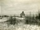
| Description: | Exterior view of the "Pottawatomie" lighthouse in snowy expanse of land, with the lake in the background. |

| Date: | 1953 |
|---|---|
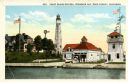
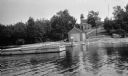
| Description: | View across water towards the Sturgeon Bay Canal Lighthouse, with a group of people in a motorboat in the foreground. |
| Date: | 1900 |
|---|---|
| Description: | View of the coast guard station from the water with multiple sailors lined up near the shore. Caption reads: "Coast Guard Station, Sturgeon Bay, Door Count... |

| Date: | 1915 |
|---|---|
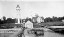
| Description: | View of the Sturgeon Bay ship canal. Caption reads: "Sturgeon Bay Ship Canal." |

| Date: | 1913 |
|---|---|
| Description: | View of the canal. Caption reads: "The Canal, Stugeon[sic] Bay, Wis." |
| Date: | |
|---|---|
| Description: | The stairs and dock at the lighthouse on Rock Island. |
| Date: | 07 07 1898 |
|---|---|
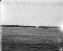
| Description: | View across water of Sturgeon Bay. In the far distance are lighthouses, buildings, and barges along the shoreline. |
| Date: | 1915 |
|---|---|
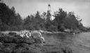
| Description: | Ferdinand Leonard (Fedy) Hotz, far left, sisters Helen, left, and Alice, sit with Thomas Toft on the rocky shore near the Baileys Harbor lighthouse. A rowb... |
| Date: | 1927 |
|---|---|
| Description: | View of the Plum Island rear range lighthouse from the end of the pier. The brick house was home to the lighthouse keeper and the first and second assistan... |
| Date: | 1920 |
|---|---|
| Description: | View from water of a man with a beard standing on a pier near a small boathouse. In the background is a lighthouse with keeper's house and outbuilding. |

| Date: | 1916 |
|---|---|
| Description: | This Wisconsin Conservation Commission map from 1916 shows Peninsula State Park in the Town of Gibraltar, Door County, Wisconsin. Depicted are open and pla... |

| Date: | 1916 |
|---|---|
| Description: | This version of a 1916 Wisconsin Conservation Commission map shows Peninsula State Park in the Town of Gibraltar, Door County, Wisconsin. Depicted are open... |

| Date: | 1930 |
|---|---|
| Description: | Aerial view from over Moonlight Bay, looking east across Bues Point to Spike Horn Bay and Cana Island. The Cana Island Lighthouse is seen as a ship passes ... |

| Date: | 1906 |
|---|---|
| Description: | Hand-colored postcard view of the Sturgeon Bay ship canal from the bay toward shore. A sailboat is on the left and a lighthouse is on shore on the right. C... |

| Date: | 1905 |
|---|---|
| Description: | This early 20th century map of Door County, Wisconsin, shows the township and range grid, towns, sections, cities and villages, landownership and acreages,... |

| Date: | 1915 |
|---|---|
| Description: | This map of Door County, Wisconsin, from the early 20th century shows roads, schools, churches, creameries and cheese factories, orchards, docks, quarries,... |
| Date: | 1962 |
|---|---|
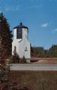
| Description: | Color postcard of a small, tower-like building on the side of a road. |

| Date: | 1950 |
|---|---|
| Description: | This map of Sturgeon Bay is part of the survey of the northern and northwestern lakes. The map shows lights, railroads, roads, and some public buildings. R... |

| Date: | 1941 |
|---|---|
| Description: | Elevated view of Sturgeon Bay in 1900. Sturgeon Bay Bridge spans the bay and several boats are on the water. A lighthouse sits on a small island in the bay... |

| Date: | 1966 |
|---|---|
| Description: | A colored map depiction of Door County, Wisconsin, with pictorial highlights, titled: "Door County — Wisconsin's Air Conditioned Peninsula Playground." |
If you didn't find the material you searched for, our Library Reference Staff can help.
Call our reference desk at 608-264-6535 or email us at: