 Filter: Categories of Wisconsin Historical Images
Filter: Subject of Lighthouses
Filter: County of Door
Filter: Categories of Wisconsin Historical Images
Filter: Subject of Lighthouses
Filter: County of Door

| Date: | 1916 |
|---|---|
| Description: | This Wisconsin Conservation Commission map from 1916 shows Peninsula State Park in the Town of Gibraltar, Door County, Wisconsin. Depicted are open and pla... |

| Date: | 1916 |
|---|---|
| Description: | This version of a 1916 Wisconsin Conservation Commission map shows Peninsula State Park in the Town of Gibraltar, Door County, Wisconsin. Depicted are open... |

| Date: | 1930 |
|---|---|
| Description: | Aerial view from over Moonlight Bay, looking east across Bues Point to Spike Horn Bay and Cana Island. The Cana Island Lighthouse is seen as a ship passes ... |

| Date: | 1906 |
|---|---|
| Description: | Hand-colored postcard view of the Sturgeon Bay ship canal from the bay toward shore. A sailboat is on the left and a lighthouse is on shore on the right. C... |
| Date: | 1908 |
|---|---|
| Description: | Hand-colored postcard view of Lover's Leap in Sturgeon Bay during winter. The view is from the frozen lake looking toward a lighthouse on shore. Caption re... |
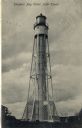
| Date: | 1908 |
|---|---|
| Description: | Postcard view of the tower. Caption reads: "Sturgeon Bay Canal Light Tower." |

| Date: | 1915 |
|---|---|
| Description: | Birch and evergreen trees line the rocky shore of Toft Point, with Cana Island and its lighthouse in the background. |

| Date: | 1905 |
|---|---|
| Description: | This early 20th century map of Door County, Wisconsin, shows the township and range grid, towns, sections, cities and villages, landownership and acreages,... |

| Date: | 1915 |
|---|---|
| Description: | This map of Door County, Wisconsin, from the early 20th century shows roads, schools, churches, creameries and cheese factories, orchards, docks, quarries,... |
| Date: | 1962 |
|---|---|
| Description: | Color postcard of a small, tower-like building on the side of a road. |

| Date: | 1950 |
|---|---|
| Description: | This map of Sturgeon Bay is part of the survey of the northern and northwestern lakes. The map shows lights, railroads, roads, and some public buildings. R... |

| Date: | 1941 |
|---|---|
| Description: | Elevated view of Sturgeon Bay in 1900. Sturgeon Bay Bridge spans the bay and several boats are on the water. A lighthouse sits on a small island in the bay... |
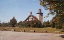
| Date: | 07 04 1947 |
|---|---|
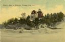
| Description: | Group of people standing in the yard in front of the lighthouse. The verso has this annotation: "'Eagle Light' Lighthouse, Peninsula Park, Fish Creek, Wi... |

| Date: | 1920 |
|---|---|
| Description: | View from beach across Spike Horn Bay towards Cana Island and the Cana Island Light. |

| Date: | 1966 |
|---|---|
| Description: | A colored map depiction of Door County, Wisconsin, with pictorial highlights, titled: "Door County — Wisconsin's Air Conditioned Peninsula Playground." |
| Date: | 1960 |
|---|---|
| Description: | Color photographic postcard view of the Cana Island U.S. Lighthouse surrounded by a green lawn. There is a hand pump near the building. |
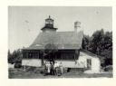
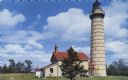
| Date: | 1957 |
|---|---|
| Description: | Color photographic postcard view of the Eagle Lighthouse in Peninsula State Park. |

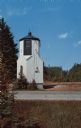
| Date: | 1962 |
|---|---|
| Description: | Color photograph of a range light built in 1870 to guide ships into the harbor at The Ridges Sanctuary, north of Bailey's Harbor, Door County. The Ridges S... |

| Date: | 01 06 1958 |
|---|---|
| Description: | View from jetty out towards Lake Michigan entrance to Ship Canal. A large tank, streetlamp and buildings are on the left. On the opposite jetty is a lighth... |

| Date: | 1900 |
|---|---|
| Description: | This blue line print map shows land use, cables, U.S.L.S.S. walk and clearing, and front and rear range lights on the Porte des Morts Passage. Tree types a... |
If you didn't find the material you searched for, our Library Reference Staff can help.
Call our reference desk at 608-264-6535 or email us at: