| Date: | 1905 |
|---|---|
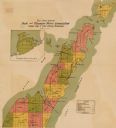
| Description: | This early 20th century map of Door County, Wisconsin, shows the township and range grid, towns, sections, cities and villages, landownership and acreages,... |

| Date: | 1915 |
|---|---|
| Description: | This map of Door County, Wisconsin, from the early 20th century shows roads, schools, churches, creameries and cheese factories, orchards, docks, quarries,... |

| Date: | 1950 |
|---|---|
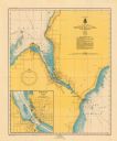
| Description: | This map of Sturgeon Bay is part of the survey of the northern and northwestern lakes. The map shows lights, railroads, roads, and some public buildings. R... |

| Date: | 1900 |
|---|---|
| Description: | This blue line print map shows land use, cables, U.S.L.S.S. walk and clearing, and front and rear range lights on the Porte des Morts Passage. Tree types a... |

| Date: | 1970 |
|---|---|
| Description: | This map shows roads, parks, swimming beaches, golf courses, yacht harbors, light houses, airports, public hunting grounds, waysides, schools, and fishing ... |
If you didn't find the material you searched for, our Library Reference Staff can help.
Call our reference desk at 608-264-6535 or email us at: