 Filter: Categories of Wisconsin Historical Images
Filter: Subject of Lead mines and mining
Filter: Subject of roads
Filter: Categories of Wisconsin Historical Images
Filter: Subject of Lead mines and mining
Filter: Subject of roads
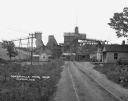
| Date: | 1925 |
|---|---|
| Description: | View down road leading up to the Cokerville Mine. Two horses pulling a wagon are near the road, and automobiles are parked on the right near a building wit... |

| Date: | 1867 |
|---|---|
| Description: | This 1867 manuscript map by Increase Lapham shows the topography and geology of the Blue Mounds region in the Town of Brigham in Iowa County and the towns ... |
If you didn't find the material you searched for, our Library Reference Staff can help.
Call our reference desk at 608-264-6535 or email us at: