Filter: Categories of Wisconsin Historical Images
Filter: Subject of Lawns
Filter: Creator Name of Gillett, Sherwin
Filter: County of Green
Filter: Categories of Wisconsin Historical Images
Filter: Subject of Lawns
Filter: Creator Name of Gillett, Sherwin
Filter: County of Green

| Date: | 1917 |
|---|---|
| Description: | View down middle of a wide dirt road in a residential area. Trees line both sides of the street along the sidewalks. |

| Date: | |
|---|---|
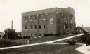
| Description: | View across dirt road of the exterior of the Brodhead High School. |
| Date: | 1917 |
|---|---|
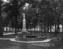
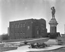
| Description: | View of a fountain in an octagonal basin at the Wisconsin Veteran's Memorial Park. There is a monument of a soldier behind it. Dwellings surround the park. |
| Date: | 1924 |
|---|---|
| Description: | View down sidewalk of two young girls standing at the base of the Soldiers Monument. There is a fountain near the monument on the right. There are benches ... |

| Date: | |
|---|---|
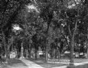
| Description: | A view down a tree-lined dirt road in a residential area. Houses and sidewalks line both sides of the road, and pedestrians are in the far background. |

| Date: | |
|---|---|
| Description: | View down a tree-lined dirt road in a residential area. A car is parked at the curb in the distance. |

| Date: | |
|---|---|
| Description: | View across lawn of the exterior of church building. In the background on the right a tent is pitched in the lot between the church and a house. |

| Date: | |
|---|---|
| Description: | View across street of a storefront at a snowy intersection. |

| Date: | |
|---|---|
| Description: | The high school building erected in 1908. The building features three stories, a bell tower, and a hip roof. A small child stands in front of the building. |
| Date: | |
|---|---|
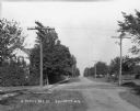
| Description: | A view down an unpaved road lined with utility poles. On the left is a sidewalk and a house partially hidden by trees. |

| Date: | |
|---|---|
| Description: | View from across street of the Farmer's Bank building on a corner. Behind the bank building are wood buildings, one of which has a sign that says, in part,... |

| Date: | |
|---|---|
| Description: | View across road of the exterior of the church. The church features a bell tower, double doors, and lancet windows. Next door, there are two houses. One ha... |

| Date: | 1925 |
|---|---|
| Description: | View from a pedestrian walkway looking towards the central business area. A concrete four-sided sign is in the center of intersection. |

| Date: | 1925 |
|---|---|
| Description: | Exterior across lawn of the three-story New Glarus high school. The school building features a decommissioned Civil War cannon near the entrance. |

| Date: | 1925 |
|---|---|
| Description: | A log cabin and park car at the Tourist Free Camp Ground. The cabin has a sign that reads, "New Glarus Settled 1845." |
| Date: | 1925 |
|---|---|
| Description: | Outside the Swingli House, near a memorial for the first New Glarus settlers. |
| Date: | 1920 |
|---|---|
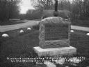
| Description: | A stone monument dedicated to the Old Lead Road. The marker reads: "The Old Lead Road. In 1828, ox-teams, guided along an ancient Winnebago Indian Trail, b... |
If you didn't find the material you searched for, our Library Reference Staff can help.
Call our reference desk at 608-264-6535 or email us at: