 Filter: Categories of Wisconsin Historical Images
Filter: Subject of Landscape architecture
Filter: Year of 1800-1899
Filter: Categories of Wisconsin Historical Images
Filter: Subject of Landscape architecture
Filter: Year of 1800-1899

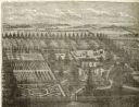
| Date: | 1879 |
|---|---|
| Description: | Bird's-eye view drawing of various buildings on the University of Wisconsin-Madison. Buildings include: Ladies Hall, South Dormitory, University Hall, Asse... |
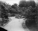
| Date: | 1893 |
|---|---|
| Description: | Extensive stonework lines the garden path at the Ceylon Building, which is originally from the Columbian Exposition in Chicago. The building was purchased ... |
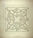
| Date: | 1872 |
|---|---|
| Description: | Drawing of the plan for the layout of the Capitol Park, drawn by Cleveland who was a landscape architect from Chicago. |
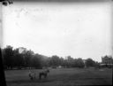
| Date: | 1899 |
|---|---|
| Description: | A man in coveralls is operating a horse-drawn mower on the grounds of a large estate or park. Several benches are on the perimeter of the grounds. |
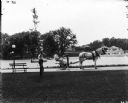
| Date: | 1899 |
|---|---|
| Description: | A male grounds keeper is driving a horse-drawn mower down a path on a park or estate grounds. Another man is leaning against a slender tree. Both men are w... |
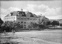
| Date: | 1880 |
|---|---|
| Description: | A view of Sacred Heart College and the surrounding landscape. Each dormer window has a cross on its peak and the center of the building has a bell tower. |

| Date: | 1863 |
|---|---|
| Description: | View of the gymnasium at Northwestern College. A staircase leads up the terraced hill to the brick building. |
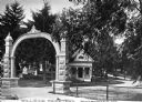
| Date: | 1870 |
|---|---|
| Description: | View of the gate and gatehouse at Hillside cemetery. Caption reads: "Hillside Cemetery, Whitewater, Wis." |
| Date: | 1878 |
|---|---|
| Description: | Engraved view of a house surrounded by gardens, an evergreen shelter belt and ornamental hedges. |
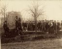
| Date: | 05 03 1892 |
|---|---|
| Description: | Tree planting ceremony on the Wooded Island during construction of the Columbian Exposition in Jackson Park. Standing to the left of the tree wrapped with ... |

| Date: | 1897 |
|---|---|
| Description: | Topographical map of Stanley McCormick's Riven Rock estate in El Montecito, Santa Barbara County, California. The map is identified as a map of a survey co... |

| Date: | 1885 |
|---|---|
| Description: | Martin K. Dahl, far left, sits with three women around a table which has been set in front of an iron fence which encloses a manicured yard. Two of the wom... |
If you didn't find the material you searched for, our Library Reference Staff can help.
Call our reference desk at 608-264-6535 or email us at: