 Filter: Categories of Wisconsin Historical Images
Filter: Subject of Landscape architecture
Filter: Subject of landscape
Filter: Subject of dwellings
Filter: Categories of Wisconsin Historical Images
Filter: Subject of Landscape architecture
Filter: Subject of landscape
Filter: Subject of dwellings
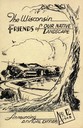
| Date: | 1948 |
|---|---|
| Description: | Cover for the 1948 Wisconsin Friends of Our Native Landscape program. Depicted is a sketch of a tree, a fence, and a small town by a lake. The Wisconsin Fr... |
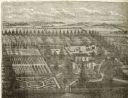
| Date: | 1878 |
|---|---|
| Description: | Engraved view of a house surrounded by gardens, an evergreen shelter belt and ornamental hedges. |

| Date: | 1897 |
|---|---|
| Description: | Topographical map of Stanley McCormick's Riven Rock estate in El Montecito, Santa Barbara County, California. The map is identified as a map of a survey co... |

| Date: | 1918 |
|---|---|
| Description: | This is a collection of two maps. One map is blue line print that includes illustrations and shows the location of buildings, gardens, plant life, and spri... |
If you didn't find the material you searched for, our Library Reference Staff can help.
Call our reference desk at 608-264-6535 or email us at: