 Filter: Categories of Wisconsin Historical Images
Filter: Subject of Landscape architecture
Filter: Subject of land
Filter: Subject of roads
Filter: Categories of Wisconsin Historical Images
Filter: Subject of Landscape architecture
Filter: Subject of land
Filter: Subject of roads
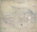
| Date: | 04 22 1915 |
|---|---|
| Description: | Topographical survey of a McCormick family property in Lake Forest, Illinois. The survey was completed for Anita McCormick [Mrs. Emmons] Blaine. The survey... |
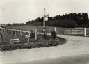
| Date: | 05 1925 |
|---|---|
| Description: | View from road of front entrance of the Speedwell Farm. Original caption reads: "Desirable farm entrance -- neat and reasonably constructed. Also showing t... |
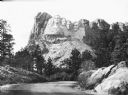
| Date: | |
|---|---|
| Description: | View of Mount Rushmore National Memorial. A road curves to the right where four presidents are depicted in the granite: George Washington, Thomas Jefferso... |

| Date: | 1897 |
|---|---|
| Description: | Topographical map of Stanley McCormick's Riven Rock estate in El Montecito, Santa Barbara County, California. The map is identified as a map of a survey co... |

| Date: | 1900 |
|---|---|
| Description: | View across manicured grounds and intertwining paths. Buildings are in the far background. On the right are buildings along a road. |
If you didn't find the material you searched for, our Library Reference Staff can help.
Call our reference desk at 608-264-6535 or email us at: