Filter: Categories of Wisconsin Historical Images
Filter: Subject of Landscape
Filter: Subject of water
Filter: Categories of Wisconsin Historical Images
Filter: Subject of Landscape
Filter: Subject of water
| Date: | 06 13 1849 |
|---|---|
| Description: | Wagon train crossing the South Platte River in Nebraska; Sketched by Wilkins on his 151-day journey from Missouri to California on the Overland Trail (also... |
| Date: | 07 10 1849 |
|---|---|
| Description: | Sweetwater River and the Red Buttes in Wyoming; sketched by Wilkins on his 151-day journey from Missouri to California on the Overland Trail (also known as... |
| Date: | 07 17 1849 |
|---|---|
| Description: | Pacific Springs, Wyoming; sketched by Wilkins on his 151-day journey from Missouri to California on the Overland Trail (also known as the Oregon Trail). Wi... |
| Date: | 07 23 1849 |
|---|---|
| Description: | Bluff near Green River, where Wilkins' wagon train crossed by ferry; sketched by Wilkins on his 151-day journey from Missouri to California on the Overland... |
| Date: | 08 03 1849 |
|---|---|
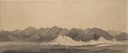
| Description: | Bear or Soda Springs along Bear River in Idaho; sketched by Wilkins on his 151-day journey from Missouri to California on the Overland Trail (also known as... |

| Date: | 1832 |
|---|---|
| Description: | Route of Military Road from Fort Crawford to Fort Howard. Map shows beginning of route at Fort Crawford. |

| Date: | 1906 |
|---|---|
| Description: | Cover of an advertising catalog for Buffalo Pitts threshers sold by International Harvester. The cover features an illustration of four buffalo standing ne... |
| Date: | 1913 |
|---|---|
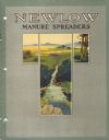
| Description: | Cover of an advertising catalog for International Harvester New Low manure spreaders. Features an illustration of a man riding on a horse-drawn manure spre... |
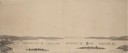
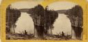
| Date: | 1880 |
|---|---|
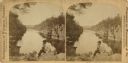
| Description: | Stereograph of the Dalles and the Saint Croix River, with one man in the center foreground sitting posing on a rock and looking to the left. On the far lef... |
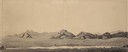
| Date: | 1880 |
|---|---|
| Description: | Stereograph of the Dalles rock formation with a two men in the foreground looking down at the Saint Croix River. On the left, one man stands leaning agains... |
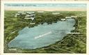
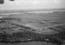
| Date: | |
|---|---|
| Description: | Aerial view of Lake Winnebago and vicinity, including Oshkosh, Fond du Lac, Neenah and Appleton. |

| Date: | 1957 |
|---|---|
| Description: | Aerial view of Yellowstone Lake and surrounding countryside. |
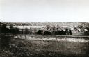
| Date: | 1893 |
|---|---|
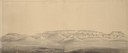
| Description: | View from the south, with a railroad in the foreground, a river in the middle distance, and Janesville in the background. |
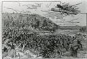
| Date: | |
|---|---|
| Description: | An illustration titled "The Battle of the Brule" based on an 1840's battle between the Ojibwe and Dakota Sioux over territory in the Ashland, Wisconsin are... |
| Date: | |
|---|---|
| Description: | Aerial view of Pennco Field (Royal Airport), the shoreline of Lake Monona, and the surrounding countryside near the city limits. |

| Date: | 1909 |
|---|---|
| Description: | View from Sunset Point in Owen Park, which is now a part of Hoyt Park. Lake Mendota is in the distance. |

| Date: | 1953 |
|---|---|
| Description: | Aerial view of La Crosse and the Mississippi River. In the foreground is the new bridge as of 1953. |

| Date: | 10 26 1986 |
|---|---|
| Description: | Green Elm Road Bridge over the east fork of Hemlock Creek, showing the rocks used to prevent erosion. |
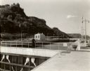
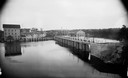
| Date: | 1935 |
|---|---|
| Description: | Locks on the Mississippi River, a nine foot channel. A man is standing above the locks. Bluffs are in the background. |
If you didn't find the material you searched for, our Library Reference Staff can help.
Call our reference desk at 608-264-6535 or email us at: