Filter: Categories of Wisconsin Historical Images
Filter: Subject of Landscape
Filter: Subject of aerial photographs
Filter: Categories of Wisconsin Historical Images
Filter: Subject of Landscape
Filter: Subject of aerial photographs

| Date: | 1958 |
|---|---|
| Description: | Aerial view of contour strip farming with the Obert Olstad farm in foreground. The Carl Backum farm is in the background. |
| Date: | |
|---|---|
| Description: | Aerial view of "Walden", the estate of Cyrus McCormick, Jr. |

| Date: | 06 1962 |
|---|---|
| Description: | Distant view of U.S helicopters over the Delta Region of South Vietnam taken by Dickey Chapelle, a freelance photographer from Milwaukee. |
| Date: | 1900 |
|---|---|
| Description: | Aerial view of town, with houses in foreground, and hills on the horizon in the background. Caption reads: "Baraboo, Wis." |
| Date: | 1900 |
|---|---|
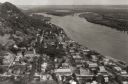
| Description: | Aerial view of town. The Mississippi River and far shoreline is in the background. The Furnace Branch creek runs through the town in the foreground. |

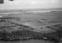
| Date: | 1930 |
|---|---|
| Description: | Aerial view of Carson Park, Half Moon Lake and part of the West Side in the foreground. The municipal bath house is on the lake shore in the foreground. A ... |
| Date: | |
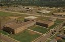
|---|---|
| Description: | Aerial view of the high school, 2100 Fenwick Avenue, and the surrounding roads. |

| Date: | |
|---|---|
| Description: | Caption reads: "Air View — Fountain City, Wis." Aerial view of town and surrounding landscape that includes trees, rolling hills, and a river. |

| Date: | 1925 |
|---|---|
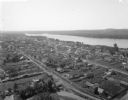
| Description: | Bird's-eye view of Fountain City looking south, with high bluff on the left, and the Mississippi River on the right. Fountain City, about 4 blocks wide, ne... |

| Date: | |
|---|---|
| Description: | Aerial view of a train crossing the East River in a rural community south of Green Bay. Some buildings are visible to the right and the background of the i... |

| Date: | 1957 |
|---|---|
| Description: | Aerial view of Yellowstone Lake and surrounding countryside. |

| Date: | 1953 |
|---|---|
| Description: | Aerial view of Wonewoc with hills or bluffs in the foreground on the right. |
| Date: | |
|---|---|
| Description: | Aerial view of Pennco Field (Royal Airport), the shoreline of Lake Monona, and the surrounding countryside near the city limits. |

| Date: | 1953 |
|---|---|
| Description: | Aerial view of La Crosse and the Mississippi River. In the foreground is the new bridge as of 1953. |

| Date: | 1955 |
|---|---|
| Description: | An aerial view of Mineral Point showing the construction of State Highway 23-39. |
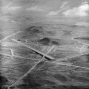
| Date: | 1954 |
|---|---|
| Description: | Aerial view of the Phoenix Proving Ground during the 1954 Industrial Power Roundup, a large event promoting International Harvester's construction equipmen... |
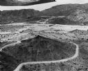
| Date: | 1966 |
|---|---|
| Description: | Aerial view of International Harvester's Phoenix Proving Ground. Opened in 1947, the proving ground was used by International Harvester through the 1970's ... |

| Date: | 11 1951 |
|---|---|
| Description: | Aerial view of US Highway 14 southeast of La Crosse descending into Mormon Coulee. The original caption of the print, which is undated, describes the road ... |
If you didn't find the material you searched for, our Library Reference Staff can help.
Call our reference desk at 608-264-6535 or email us at: